Wikipedia portal for content related to Myanmar (Burma)
ကြိုဆိုပါတယ်။ / Welcome to the Myanmar Portal
Myanmar, officially the Republic of the Union of Myanmar and also known as Burma (the official name until 1989), is a country in Southeast Asia. It is the largest country by area in Mainland Southeast Asia and has a population of about 55 million. It is bordered by Bangladesh and India to its northwest, China to its northeast, Laos and Thailand to its east and southeast, and the Andaman Sea and the Bay of Bengal to its south and southwest. The country's capital city is Naypyidaw, and its largest city is Yangon (formerly Rangoon).
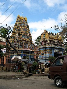
Shri Kali Temple, Burma, a Hindu temple with Dravidian architecture in YangonBurmese Indians are a group of people of Indian origin who live in Myanmar (Burma). The term 'Burmese Indian' refers to a broad range of people from South Asia, most notably from present-day countries such as India and Bangladesh. While Indians have lived in Burma for many centuries, most of the ancestors of the current Burmese Indian community emigrated to Burma from the start of British rule in the mid-19th century to the separation of British Burma from British India in 1937. During colonial times, ethnic Indians formed the backbone of the government and economy serving as soldiers, civil servants, merchants, moneylenders, mobile laborers and dock workers. A series of anti-Indian riots in the 1930s and mass emigration at the onset of the Japanese invasion of Burma in 1942 were followed in the 1960s by the forced migration of hundreds of thousands of ethnic Indians, exacerbated by internal conflict in Myanmar.
Burmese Indians today are estimated to account for approximately 5% (about 2.0–2.5 million people) of the population of Burma and are concentrated largely in the two major cities (Yangon and Mandalay) and former colonial towns (Pyin U Lwin and Kalaw). They wield considerable influence and control over the Burmese economy and have a major socio-cultural presence within the country. Amongst the well-known Burmese Indians is S N Goenka, a leading practitioner and teacher of vipassanā meditation and Helen, a well-known Bollywood film actress who is also of Anglo-Burmese descent. (Full article...)
The casus belli have been stated as a Burmese attempt to expand their territory eastwards after a political crisis in Ayutthaya as well as an attempt to stop Siamese incursions into the upper Tenasserim coast. The war, according to the Burmese, began in January 1547 when Siamese forces conquered the frontier town of Tavoy (Dawei). Later in the year, the Burmese forces led by Gen. Saw Lagun Ein retook the Upper Tenasserim coast down to Tavoy. Next year, in October 1548, three Burmese armies led by King Tabinshwehti and his deputy Bayinnaung invaded Siam through the Three Pagodas Pass. The Burmese forces penetrated up to the capital city of Ayutthaya but could not take the heavily fortified city. One month into the siege, Siamese counterattacks broke the siege, and drove back the invasion force. But the Burmese negotiated a safe retreat in exchange for the return of two important Siamese nobles (the heir apparent Prince Ramesuan, and Prince Thammaracha of Phitsanulok) whom they had captured. (Full article...)
Image 3
Dein Mani-Yut (Mon: ဒိန်ၝိတ်ရတ်; Burmese: ဒိန်မဏိရွတ်, Burmese pronunciation:[dèiɴmənḭjʊ̯ʔ]), commonly known as Amat Dein (အမတ်ဒိန်, "Minister Dein") or as Amat Tein (အမတ်တိန်, "Minister Tein"), was co-chief minister of Hanthawaddy during the reign of King Razadarit (1384–1421). He was also a senior general, and held key governorship posts at Syriam (1370s–1408), Bassein (1408–1415) and Sittaung (1415–1420s). Along with his colleague Byat Za, Dein was instrumental in Razadarit's reunification campaigns of the Mon-speaking kingdom in the late 1380s, as well as the Forty Years' War against the Burmese-speaking Ava Kingdom. (Full article...)
The Thadingyut Festival (Burmese: သီတင်းကျွတ်ပွဲတော်), also known as the Lighting Festival of Myanmar, is held on the full moon day of the Burmese lunar month of Thadingyut. As a custom, it is held at the end of the Buddhist sabbath (Vassa) and is the second most popular festival in Myanmar after Thingyan Festival (New Year Water Festival). Thadingyut festival is the celebration to welcome the Buddha’s descent from the heaven after he preached the Abhidhamma to his mother, Maya, who was reborn in the heaven. (Full article...)
Another group, the Bamar people, entered the upper Irrawaddy valley in the early 9th century. They went on to establish the Pagan Kingdom (1044–1297), the first-ever unification of the Irrawaddy valley and its periphery. The Burmese language and culture slowly came to replace Pyu norms during this period. After the First Mongol invasion of Burma in 1287, several small kingdoms, of which the Kingdom of Ava, the Hanthawaddy Kingdom, the Kingdom of Mrauk U and the Shan States were principal powers, came to dominate the landscape, replete with ever-shifting alliances and constant wars. (Full article...)
Image 7
Shan State (Shan: မိူင်းတႆး, Möng Tai; Burmese: ရှမ်းပြည်နယ်, pronounced[ʃáɰ̃pjìnɛ̀]) is a state of Myanmar. Shan State borders China (Yunnan) to the north, Laos (Louang Namtha and Bokeo Provinces) to the east, and Thailand (Chiang Rai, Chiang Mai and Mae Hong Son Provinces) to the south, and five administrative divisions of Myanmar in the west. The largest of the 14 administrative divisions by land area, Shan State covers 155,800 km2, almost a quarter of the total area of Myanmar. The state gets its name from Burmese name for the Tai peoples: "Shan people". The Tai (Shan) constitute the majority among several ethnic groups that inhabit the area. Shanland is largely rural, with only three cities of significant size: Lashio, Kengtung, and the capital, Taunggyi. Taunggyi is 150.7 km northeast of the nation's capital Naypyitaw.
The Shan state, with many ethnic groups, is home to several armed ethnic groups. While the military government has signed ceasefire agreements with most groups, vast areas of the state, especially those east of the Salween River, remain outside the central government's control, and in recent years have come under heavy ethnic-Han Chinese economic and political influence. Other areas are under the control of military groups such as the Shan State Army. (Full article...)
In 1942, Japan invaded Burma and, on 1 August 1943, nominally declared the colony independent as the State of Burma. A pro-Japanese government led by Ba Maw was installed. However, many Burmese began to believe the Japanese had no intention of giving them real independence. (Full article...)
... that clashes between the Myanmar military and local armed groups broke out in Lay Kay Kaw six years after it was established as a "town of peace" between the parties?
Image 3Political Map of Burma (Myanmar) c. 1450 CE. (from History of Myanmar)
Image 4The shores of Irrawaddy River at Nyaung-U, Bagan (from Geography of Myanmar)
Image 5British soldiers dismantling cannons belonging to King Thibaw's forces, Third Anglo-Burmese War, Ava, 27 November 1885. Photographer: Hooper, Willoughby Wallace (1837–1912). (from History of Myanmar)
Image 16A wedding procession, with the groom and bride dressed in traditional Burmese wedding clothes, reminiscent of royal attire (from Culture of Myanmar)
Image 17A theatrical performance of the Mon dance (from Culture of Myanmar)
Image 19British soldiers remove their shoes at the entrance of Shwedagon Pagoda. To the left, a sign reads "Foot wearing is strictly prohibited" in Burmese, English, Tamil, and Urdu. (from Culture of Myanmar)
Image 20The paddle steamer Ramapoora (right) of the British India Steam Navigation Company on the Rangoon river having just arrived from Moulmein. 1895. Photographers: Watts and Skeen (from History of Myanmar)
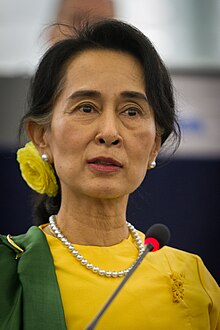
Image 21Protesters in Yangon carrying signs reading "Free Daw Aung San Suu Kyi" on 8 February 2021. (from History of Myanmar)
Image 22Recorder's Court on Sule Pagoda Road, with the Sule Pagoda at the far end, Rangoon, 1868. Photographer: J. Jackson. (from History of Myanmar)
Image 23Pagan Kingdom during Narapatisithu's reign. Burmese chronicles also claim Kengtung and Chiang Mai. Core areas shown in darker yellow. Peripheral areas in light yellow. Pagan incorporated key ports of Lower Burma into its core administration by the 13th century. (from History of Myanmar)
Image 34Salween river at Mae Sam Laep on the Thai-Myanmar border (from Geography of Myanmar)
Image 35Portuguese ruler and soldiers mounting an Elephant. Philips, Jan Caspar (draughtsman and engraver) (from History of Myanmar)
Image 36Vegetable stall on the roadside at the Madras Lancer Lines, Mandalay, January 1886. Photographer: Hooper, Willoughby Wallace (1837–1912). (from History of Myanmar)


.svg)


 Political Map of Burma (Myanmar) c. 1450 CE. (from History of Myanmar)
 The shores of Irrawaddy River at Nyaung-U, Bagan (from Geography of Myanmar)
 British soldiers dismantling cannons belonging to King Thibaw's forces, Third Anglo-Burmese War, Ava, 27 November 1885. Photographer: Hooper, Willoughby Wallace (1837–1912). (from History of Myanmar)
 A bull fight, 19th-century watercolour (from Culture of Myanmar)
 Aerial view of a burned Rohingya village in Rakhine state, Myanmar, September 2017 (from History of Myanmar)
 A wide range of Burmese lacquerware from Bagan (from Culture of Myanmar)
 Saint Mary's Cathedral in Downtown Yangon is the largest Roman Catholic cathedral in Burma. (from Culture of Myanmar)
 Former US President Barack Obama poses barefoot on the grounds of Shwedagon Pagoda, one of Myanmar's major Buddhist pilgrimage sites. (from Culture of Myanmar)
 British soldiers on patrol in the ruins of the Burmese town of Bahe during the advance on Mandalay, January 1945. (from History of Myanmar)
 Protesters in Yangon with a banner that reads non-violence: national movement in Burmese, in the background is Shwedagon Pagoda. (from History of Myanmar)
 Two female musicians play the saung at a performance in Mandalay. (from Culture of Myanmar)
 Myinhkin thabin - equestrian sport (from Culture of Myanmar)
 A wedding procession, with the groom and bride dressed in traditional Burmese wedding clothes, reminiscent of royal attire (from Culture of Myanmar)
 A theatrical performance of the Mon dance (from Culture of Myanmar)
 British soldiers remove their shoes at the entrance of Shwedagon Pagoda. To the left, a sign reads "Foot wearing is strictly prohibited" in Burmese, English, Tamil, and Urdu. (from Culture of Myanmar)
 The paddle steamer Ramapoora (right) of the British India Steam Navigation Company on the Rangoon river having just arrived from Moulmein. 1895. Photographers: Watts and Skeen (from History of Myanmar)
 Protesters in Yangon carrying signs reading "Free Daw Aung San Suu Kyi" on 8 February 2021. (from History of Myanmar)
 Recorder's Court on Sule Pagoda Road, with the Sule Pagoda at the far end, Rangoon, 1868. Photographer: J. Jackson. (from History of Myanmar)
 Pagan Kingdom during Narapatisithu's reign. Burmese chronicles also claim Kengtung and Chiang Mai. Core areas shown in darker yellow. Peripheral areas in light yellow. Pagan incorporated key ports of Lower Burma into its core administration by the 13th century. (from History of Myanmar)
 Temples at Mrauk U, was the capital of the Mrauk U Kingdom, which ruled over what is now Rakhine State. (from History of Myanmar)
 Hlei pyaingbwè - a Burmese regatta (from Culture of Myanmar)
 A group of Buddhist worshipers at Shwedagon Pagoda, an important religious site for Burmese Buddhists (from Culture of Myanmar)
 Boxing match, 19th-century watercolour (from Culture of Myanmar)
 Mountains near Pindaya on the Shan Plateau (from Geography of Myanmar)
 Jade Mine in Hpakant (from Geography of Myanmar)
 Grandfather Island, Dawei (from Geography of Myanmar)
 Myanmar (Burma) map of Köppen climate classification (from Geography of Myanmar)
 The restored Taungoo or Nyaungyan dynasty c. 1650 CE. (from History of Myanmar)
 A large fracture on the Mingun Pahtodawgyi caused by the 1839 Ava earthquake. (from Geography of Myanmar)
 Salween river at Mae Sam Laep on the Thai-Myanmar border (from Geography of Myanmar)
 Portuguese ruler and soldiers mounting an Elephant. Philips, Jan Caspar (draughtsman and engraver) (from History of Myanmar)
 Vegetable stall on the roadside at the Madras Lancer Lines, Mandalay, January 1886. Photographer: Hooper, Willoughby Wallace (1837–1912). (from History of Myanmar)
 Aung San Suu Kyi addresses crowds at the NLD headquarters shortly after her release. (from History of Myanmar)
 19th-century funeral cart and spire, which would form part of the procession from the home to the place of cremation (from Culture of Myanmar)
 Sculpture of Myanmar mythical lion (from Culture of Myanmar)
 Mount Popa, a dormant volcano in the Central Lowlands (from Geography of Myanmar)


_headquarter.jpg)


 Commons
 Wikibooks
 Wikidata
 Wikinews
 Wikiquote
 Wikisource
 Wikiversity
 Wikivoyage
 Wiktionary


