Pontmain
Pontmain | |
|---|---|
 The basilica of Our Lady of Pontmain | |
.svg) Coat of arms | |
Location of Pontmain  | |
 Pontmain  Pontmain | |
| Coordinates: 48°26′22″N 1°03′26″W / 48.4394°N 1.0572°W | |
| Country | France |
| Region | Pays de la Loire |
| Department | Mayenne |
| Arrondissement | Mayenne |
| Canton | Gorron |
| Government | |
| • Mayor (2020–2026) | Marie-Antoinette Guesdon[1] |
| Area 1 | 7.17 km2 (2.77 sq mi) |
| Population (2021)[2] | 807 |
| • Density | 110/km2 (290/sq mi) |
| Time zone | UTC+01:00 (CET) |
| • Summer (DST) | UTC+02:00 (CEST) |
| INSEE/Postal code | 53181 /53220 |
| Elevation | 134–210 m (440–689 ft) (avg. 180 m or 590 ft) |
| 1 French Land Register data, which excludes lakes, ponds, glaciers > 1 km2 (0.386 sq mi or 247 acres) and river estuaries. | |
Pontmain (French pronunciation: [pɔ̃mɛ̃]) is a commune in the Mayenne department in north-western France.
History
On 17 January 1871, some children from the village claimed to see an apparition of the Virgin Mary in the sky. On 2 February 1872 Mgr. Wicart, bishop of Laval, recognised the apparition. :
Nous jugeons que l'Immaculée Vierge Marie, Mère de Dieu a véritablement apparu, le 17 janvier 1871, à Eugène Barbedette, Joseph Barbedette, Françoise Richer et Jeanne-Marie Lebossé, dans le hameau de Pontmain.
We judge that the immaculate Virgin Mary, mother of God has veritably appeared, on 17 January 1871, to Eugène Barbedette, Joseph Barbedette, Françoise Richer and Jeanne-Marie Lebossé, in the hamlet of Pontmain.
A new church was built in the commune after this apparition between 1873 and 1877. It was erected with a basilica by Pope Pius X in 1908. During World War I, a concentration camp existed in Pontmain. This camp was reserved for civil inmates who lived there with families. In the camp were inmates from Austria, Alsace, Lorraine, Belgium, Luxembourg, Ottoman Empire etc. On 1 July 1972, the municipalities of Saint-Ellier-du-Maine and Saint-Mars-sur-la-Futais was associated with Pontmain. This association was dissolved on 1 January 1983.
The railroad
Pontmain was served by the departmental railroad line connecting Laval to Landivy. This line was opened on 18 December 1901. Its closure was decided by the county council on 22 May 1938.
See also
Illustrations
-
 Witness of the apparition in 1871
 -
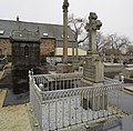 Remembering of Barbedette family and abbot's Cuérin tomb (center)


References
- ^ "Répertoire national des élus: les maires" (in French). data.gouv.fr, Plateforme ouverte des données publiques françaises. 13 September 2022.
- ^ "Populations légales 2021" (in French). The National Institute of Statistics and Economic Studies. 28 December 2023.
| International | |
|---|---|
| National | |
This Mayenne geographical article is a stub. You can help Wikipedia by expanding it. |
- Pages using gadget WikiMiniAtlas
- CS1 French-language sources (fr)
- Use dmy dates from August 2023
- Articles with short description
- Short description is different from Wikidata
- Coordinates on Wikidata
- Pages using infobox settlement with image map1 but not image map
- Pages with French IPA
- Commons category link from Wikidata
- Articles with VIAF identifiers
- Articles with BNF identifiers
- Articles with BNFdata identifiers
- Communes of Mayenne
- Catholic Church in France
- Catholic pilgrimage sites
- Shrines to the Virgin Mary
- All stub articles
- Mayenne geography stubs
- Pages using the Kartographer extension