Pollard, Kansas
Pollard, Kansas | |
|---|---|
 | |
 Pollard  Pollard | |
| Coordinates: 38°26′59″N 98°12′38″W / 38.44972°N 98.21056°W[1] | |
| Country | United States |
| State | Kansas |
| County | Rice |
| Township | Victoria |
| Elevation | 1,736 ft (529 m) |
| Time zone | UTC-6 (CST) |
| • Summer (DST) | UTC-5 (CDT) |
| Area code | 620 |
| FIPS code | 20-56975 |
| GNIS ID | 484741[1] |
Pollard is an unincorporated community in Victoria Township, Rice County, Kansas, United States.[1] It lies a fraction of a mile (about 1 km) west of K-14, 6 miles (9.7 km) southwest of Geneseo and 7 miles (11 km) north of Lyons.[2]
History
For millennia, the land now known as Kansas was inhabited by Native Americans. In 1803, most of modern Kansas was secured by the United States as part of the Louisiana Purchase. In 1854, the Kansas Territory was organized, then in 1861 Kansas became the 34th U.S. state. In 1867, Rice County was founded.
Pollard had a post office from 1888 until 1923.[3]
Education
The community is served by Lyons USD 405 public school district.
References
- ^ a b c d U.S. Geological Survey Geographic Names Information System: Pollard, Kansas
- ^ DeLorme. Kansas Atlas & Gazetteer. 4th ed. Yarmouth: DeLorme, 2009, p. 47. ISBN 0-89933-342-7.
- ^ "Kansas Post Offices, 1828-1961". Kansas Historical Society. Archived from the original on October 9, 2013. Retrieved June 22, 2014.
Further reading
External links
Municipalities and communities of Rice County, Kansas, United States | ||
|---|---|---|
| Cities | 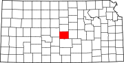 | |
| Unincorporated communities | ||
| Ghost towns | ||
| Townships | ||
This article about a location in Rice County, Kansas is a stub. You can help Wikipedia by expanding it. |
- Pages using gadget WikiMiniAtlas
- Articles with short description
- Short description matches Wikidata
- Use mdy dates from July 2023
- Short description is different from Wikidata
- Coordinates on Wikidata
- Pages using infobox settlement with image map1 but not image map
- Unincorporated communities in Kansas
- Unincorporated communities in Rice County, Kansas
- All stub articles
- South-Central Kansas geography stubs