Pico Ruivo
Jump to navigation
Jump to search
| Pico Ruivo | |
|---|---|
 | |
| Highest point | |
| Elevation | 1,861 m (6,106 ft)[1] |
| Prominence | 1,861 m (6,106 ft)[1] |
| Listing | Ultra |
| Coordinates | 32°45′31″N 16°56′32″W / 32.75861°N 16.94222°W[1] |
| Geography | |
 Pico Ruivo Location of Pico Ruivo in Madeira | |
| Location | Madeira |
| Climbing | |
| Easiest route | From Achada do Teixeira |
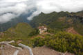
Pico Ruivo is the highest peak on Madeira Island. It can be reached only by foot, usually either from Pico do Areeiro (3rd highest) after a strenuous hike, or from Achada do Teixeira via a shorter, easier trail. There is an additional trail leading west to Encumeada. The hut just below the summit is now open, and there are water tap and toilets available.
Pico Ruivo is 1,861 metres (6,106 ft) high [2] and provides panoramic views of the island from coast to coast, but unpredictable weather conditions can make it quite dangerous.
-
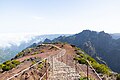
 Platform on the summit of Pico Ruivo.
 -
 Shelter below the summit.
 -
 Summit from the viewing platform in the northwest.
 -
 Second viewing platform, northwest from the summit.
 -
 View towards Pico das Torres and Pico Ruivo from Pico do Arieiro.


See also
References
- ^ a b c "Europe: Atlantic Islands - Ultra Prominences" Peaklist.org. Retrieved 2012-06-28.
- ^ Madeira Geography - Madeira Island and Porto Santo Island Archived 2011-07-14 at the Wayback Machine
External links
![]() Media related to Pico Ruivo at Wikimedia Commons
Media related to Pico Ruivo at Wikimedia Commons
This Madeira location article is a stub. You can help Wikipedia by expanding it. |
Categories:
- Pages using gadget WikiMiniAtlas
- Webarchive template wayback links
- Articles with short description
- Short description is different from Wikidata
- Coordinates on Wikidata
- Commons category link from Wikidata
- Geography of Madeira
- Mountains of Portugal
- Tourist attractions in Madeira
- One-thousanders of Portugal
- All stub articles
- Autonomous Region of Madeira stubs
- Portugal geography stubs