Omar, West Virginia
Jump to navigation
Jump to search
Omar, West Virginia | |
|---|---|
 Omar | |
 Omar  Omar | |
| Coordinates: 37°45′20″N 81°59′58″W / 37.75556°N 81.99944°W | |
| Country | United States |
| State | West Virginia |
| County | Logan |
| Area | |
| • Total | 1.140 sq mi (2.95 km2) |
| • Land | 1.125 sq mi (2.91 km2) |
| • Water | 0.015 sq mi (0.04 km2) |
| Elevation | 814 ft (248 m) |
| Population | |
| • Total | 552 |
| • Density | 490.7/sq mi (189.5/km2) |
| Time zone | UTC-5 (Eastern (EST)) |
| • Summer (DST) | UTC-4 (EDT) |
| ZIP code | 25638 |
| Area code(s) | 304 & 681 |
| GNIS feature ID | 1544403[3] |
| FIPS code | 54-60628 |
Omar is an unincorporated community and census-designated place (CDP) in Logan County, West Virginia, United States. Omar is located along West Virginia Route 44 and Island Creek, 6.5 miles (10.5 km) south of Logan.[4] Omar has a post office with ZIP code 25638.[5] As of the 2010 census, its population was 552.[2]
The community was named after James Omar Cole, one of the original lessors.[6]
-
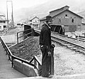 Omar in 1935
.jpg)
References
- ^ "2020 U.S. Gazetteer Files – West Virginia". United States Census Bureau. Retrieved March 17, 2021.
- ^ a b "Total Population: 2010 Census DEC Summary File 1 (P1), Omar CDP, West Virginia". data.census.gov. U.S. Census Bureau. Retrieved March 17, 2021.
- ^ U.S. Geological Survey Geographic Names Information System: Omar, West Virginia
- ^ West Virginia Atlas & Gazetteer. Yarmouth, Me.: DeLorme. 1997. p. 57. ISBN 0-89933-246-3.
- ^ ZIP Code Lookup
- ^ Swain, George T. "A History of the City of Logan, West Virginia: 1823-1916 (p. 117)". Retrieved March 6, 2022.

This article about a location in Logan County, West Virginia is a stub. You can help Wikipedia by expanding it. |
Categories:
- Pages using gadget WikiMiniAtlas
- Use mdy dates from July 2023
- Articles with short description
- Short description is different from Wikidata
- Coordinates on Wikidata
- Pages using infobox settlement with possible area code list
- Census-designated places in Logan County, West Virginia
- Census-designated places in West Virginia
- Coal towns in West Virginia
- All stub articles
- Logan County, West Virginia geography stubs