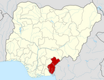
Obubra
This article needs additional citations for verification. (June 2020) |
Obubra | |
|---|---|
LGA and town | |
| Coordinates: 6°05′0″N 8°20′0″E / 6.08333°N 8.33333°E | |
| Country | |
| State | Cross River State |
| Government | |
| • Local Government Chairman | Bassey Agara Tom |
| Area | |
| • Total | 431 sq mi (1,115 km2) |
| Time zone | UTC+1 (WAT) |
| Website | www |
 | |
Obubra is a Local Government Area (LGA) of Cross River State, Nigeria.[1] Its headquarters are in the town of Obubra, which is home to the Ibrahim Babangida College of Agriculture.
The National Youth Service Corps, Cross River State Orientation Camp is situated in Obubra town.[2]
The word Obubra is derived from 'Ubibira or Ubira', the name of Obubra main village at the bank of the Cross river. Obubra however, was used to represent an administrative unit under the British colonial empire in the late 19th century. The exact history of the signed treaties of Community heads and the representatives of the British empire are in antiquity.
It covered areas bounded by Abakaliki and Ikom to the North, and Afikpo and Calabar to the South. This meant that its jurisdiction extended from parts of present-day Biase and Akamkpa local government areas through Abi, Yakurr and Etung to parts of Ikom and Ogoja local government areas.
Presently Obubra Local Government Area has eleven Council wards of Ababene, Ofat, Ofodua, Ovonum, Apiapum, Iyamoyong, Ochon, Obubra Urban, Ofumbongha/Yala, Osopong I and Osopong II.
Most of the communities emerged as settlements of intercommunal wars. The lines of friction which had existed from ancestral origin are heated up and the people divided by their political elites who disagree to agree on a common political leadership or a channel for socioeconomic development of Obubra Urban, wherein lies the headquarters, and then spread to all communities. Obubra has 98 villages some of which include; Obubra Village, Ogada, Owakande, Imabana Itamtet, Apiapum, Yala, Iyamoyong, Ohana, Ochon, Isabang, Ovunom, Ofodua, Ofat, Ababene, Oderegha, Okorogbana, Onyedama, Ebo, and Iko, Ogurude, Ofonmana, Ogurokpon, Okimbongha, Ofonagama, Omene, Ofonamma, Ofonekom, Appiapumtet, Idoru 1 and 2, Ijutum, Eja, Ijagha Orangha, Aragharagha, Ogamina, the list continuous.
It has an area of 1,115 km2 and a population of 172,444 at the 2006 census. St. Francis Xavier Parish, which today has given birth to five(5) other parishes, was originally founded in 1965. However, the first Holy Mass was celebrated in 1961, as missionaries visited to source for land for a Secondary school (St Brendan's) later located at Iyamoyong, about 15 kilometers away. The Chiefs and opinion leaders involved in the location of St Francis Xavier were: Chief Ibingha Ogbosohu, Chief Okpa Irek Okpa, and Chief Ewona Okpa all of Obubra Village, and Chief Egbara (Kwididen Kwosopong) Clan Head.<A History of the Catholic Church in Ogoja region (1921-2021) Evolution of Parishes,institutions, Clergy, Religious and key Lay Personnel by Catholic Diocese of Ogoja> Obubra Village celebrated Abu festival 2024. This festival comes up once in seven years. It was a showcase of all-male dancing from the oldest age-grade to the youngest. Mr Ekong Okpa wrote about the Abu festival called Ort'bha in the Osopong dialect, in the Newsfeature of the Weekend Chronicle where he is the Editor. The article published on Friday June 21, 2024 was titled (Ort'bha festival:A heritage of the Osopong Kingdom....Survey for sustainability). Mr Ekong likened the festival to the popular Argungu fishing festival of Kebbi, Agoye festival of ancient Benin Kingdom, and the colourful festival of the Ashante Henes of ancient Ashante Kingdom. he noted that Obubra Village started Ort'bha festival in the 1800s, and traced the origin of the festival to Agwagwune in present day Biase Local Government area, whose people shade trade relationship along the banks of the Cross river with Obubra Village. He noted that in 1902 the British colonial masters established the administrative headquaters of Obubra on Obubra hill, while the Village was at the bank of the Cross river. He mentioned Major Crawford Cockboun who wrote 'a documentary on Obubra entry book' in 1903. He stated that Ort'bha festival was to promote the cultural heritage of the people with activities such as wrestling challenges, exchang of gifts, traditional dress patterns and display of physical fitness. He noted that in 1969, the Military officers and soldiers took part in the Ort'bha festival, and they danced to the tones in synchrony to rhythms of the wooden drums. He presumed that the endurance trek introduced by the National Youth Service Scheme (NYSC) may have been reminiscent of the long distance trek associated with Ort'bha festival.
The postal code of the area is 551.[3]
References
- ^ "Cross River State". Cross River Hub. Retrieved 2021-09-11.
- ^ "LIST OF INSTITUTIONS FOR 2008 BATCH 'B' SERVICE YEAR". National Youth Services Corp. Archived from the original on 2011-07-24. Retrieved 2010-03-21.
- ^ "Post Offices- with map of LGA". NIPOST. Archived from the original on 2012-11-26. Retrieved 2009-10-20.
Peter Obele Abue. A History of the evolution of the Catholic Church in Ogoja Region (1921-2021), Catholic Diocese of Ogoja 2021, Volume II page 30
Ekong Okpa. Ort'bha festival: A heritage of the Osopong Kingdom.... a survey for sustainability. Weekend Chronicle, Friday, June 21, 2024
- Pages using gadget WikiMiniAtlas
- Use Nigerian English from January 2023
- Articles needing additional references from June 2020
- All articles needing additional references
- Articles with short description
- Short description is different from Wikidata
- Coordinates on Wikidata
- Infobox mapframe without OSM relation ID on Wikidata
- Articles with VIAF identifiers
- Articles with WorldCat Entities identifiers
- Articles with J9U identifiers
- Articles with LCCN identifiers
- Local Government Areas in Cross River State
- All stub articles
- Cross River state geography stubs
- Pages using the Kartographer extension

