Micanopy Historic District
Jump to navigation
Jump to search
This article lacks inline citations besides NRIS, a database which provides minimal and sometimes ambiguous information. (November 2013) |
Micanopy Historic District | |
 Herlong Mansion in the Micanopy Historic District | |
  | |
| Location | Micanopy, Florida |
|---|---|
| Coordinates | 29°30′21″N 82°16′58″W / 29.50583°N 82.28278°W |
| Area | 470 acres (1.9 km2) |
| Built | 1776 |
| NRHP reference No. | 83003512[1] |
| Added to NRHP | January 28, 1983 |
The Micanopy Historic District is a U.S. historic district (designated as such on January 28, 1983) located in Micanopy, Florida. It encompasses approximately 470 acres (1.9 km2), bounded by roughly Cholokka Boulevard from US 441 to Ocala Street then Smith Street West to Okehumkee Street. It contains 35 historic buildings.
Gallery
Churches
-
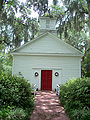 Presbyterian Church, now Episcopal Church of the Mediator.
 -
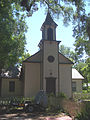 Old Baptist Church, now a private house.


Houses
-
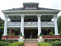 Herlong House, now a bed and breakfast
 -
 Simonton House


See also
Wikimedia Commons has media related to National Register of Historic Places in Micanopy, Florida.
References
External links
- Florida's Office of Cultural and Historical Programs - Alachua County
- Historic Markers in Alachua County

This article about a property in Alachua County, Florida on the National Register of Historic Places is a stub. You can help Wikipedia by expanding it. |
Categories:
- Pages using gadget WikiMiniAtlas
- Articles using NRISref without a reference number
- Articles with short description
- Short description is different from Wikidata
- Use mdy dates from August 2023
- Articles sourced only to NRIS from November 2013
- All articles sourced only to NRIS
- Coordinates on Wikidata
- NRHP infobox with nocat
- Commons category link is on Wikidata
- National Register of Historic Places in Alachua County, Florida
- Historic districts on the National Register of Historic Places in Florida
- All stub articles
- North Central Florida Registered Historic Place stubs