Mahabad River
Jump to navigation
Jump to search

The Mahabad (Persian: مهابادرود, Sorani Kurdish: چۆمی مەهابادێ, Kurdish: çomî Mehabadê) is an endorheic river in Mahabad county Iran, located at 36°46′03″N 45°42′06″E and which flows into the southern end of Lake Urmia. The Kauter and Beytas Rivers originate from the southern heights of the plain and run to the north in parallel. They join and create the Mahabad Dam reservoir and continue running as the Mahabad River.[1]
The river has been crossed by the Mahabad Dam near the city of Mahabad, West Azerbaijan province.
-
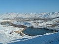 Mahabad in December 2006
 -
 Mahabad Dam at night
 -
 Soor Bridge, 1920s
 -
 Mahabad river at southern Lake Urmia, from an 1861 map


._Turkey_in_Asia,_Transcaucasia._1861_(GFB).jpg)
See also
References
- ^ Nazari-Sharabian, Mohammad; Taheriyoun, Masoud; Ahmad, Sajjad; Karakouzian, Moses; Ahmadi, Azadeh (February 2019). "Water Quality Modeling of Mahabad Dam Watershed–Reservoir System under Climate Change Conditions, Using SWAT and System Dynamics". Water. 11 (2): 394. doi:10.3390/w11020394. ISSN 2073-4441.
| Lake Urmia basin | |
|---|---|
| Persian Gulf basin | |
| Oman sea basin | |
| Caspian basin | |
| Gavkhouni basin | |
| Namak Lake basin | |
| Hamun-e Jaz Murian basin | |
| Other | |
Categories:
- Articles containing Persian-language text
- Articles containing Sorani Kurdish-language text
- Articles containing Kurdish-language text
- West Azerbaijan province articles missing geocoordinate data
- All articles needing coordinates
- Articles missing coordinates with coordinates on Wikidata
- Rivers of West Azerbaijan Province
- Landforms of West Azerbaijan province
- Iranian Kurdistan
- All stub articles
- Iran river stubs