Little Cacapon Mountain
| Little Cacapon Mountain | |
|---|---|
 Little Cacapon Mountain viewed from Ginevan Cemetery near Little Cacapon, West Virginia. | |
| Highest point | |
| Elevation | 1,575 ft (480 m) |
| Coordinates | 39°21′00″N 78°36′37″W / 39.3500986°N 78.6102908°W[1] |
| Geography | |
| Location | Hampshire County. West Virginia, U.S. |
| Parent range | Ridge-and-Valley Appalachians |
| Topo map | USGS Hanging Rock, Levels |
| Climbing | |
| Easiest route | Hike, drive |
Little Cacapon Mountain (locally /kəˈkeɪpən/ kə-KAY-pən or locally /ˈkeɪpən/ KAY-pən) is a mountain ridge of the Ridge-and-valley Appalachians in Hampshire County, West Virginia, United States. The mountain takes its name from the Little Cacapon River, a Potomac River tributary that lies on its western flanks. Little Cacapon Mountain reaches its highest point of 1,575 feet (480 m) in the vicinity of Barnes Mill. It spans from the Frenchburg area, where it is joined by Chestnut Oak Ridge, to the Slanesville Pike where Crooked Run forms a gap between Little Cacapon Mountain and Queens Ridge near Higginsville.
Gallery
-
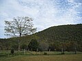 Little Cacapon Mountain viewed from Ginevan Cemetery near Little Cacapon
 -
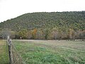 Little Cacapon Mountain viewed from Ginevan Cemetery near Little Cacapon
 -
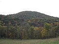 Little Cacapon Mountain viewed from Ginevan Cemetery near Little Cacapon


References
External links
![]() Media related to Little Cacapon Mountain at Wikimedia Commons
Media related to Little Cacapon Mountain at Wikimedia Commons
This article is about a location in Hampshire County, West Virginia is a stub. You can help Wikipedia by expanding it. |
- Pages using gadget WikiMiniAtlas
- Articles with short description
- Short description matches Wikidata
- Coordinates on Wikidata
- Commons category link from Wikidata
- Ridges of Hampshire County, West Virginia
- Ridges of West Virginia
- West Virginia placenames of Native American origin
- All stub articles
- Hampshire County, West Virginia geography stubs