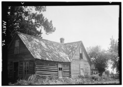
Hazard, Washington
Jump to navigation
Jump to search
Hazard | |
|---|---|
 Hazard Post Office | |
| Coordinates: 47°52′40″N 117°31′08″W / 47.87778°N 117.51889°W | |
| Country | United States |
| State | Washington |
| County | Spokane |
| Elevation | 2,145 ft (654 m) |
| Time zone | UTC-8 (Pacific (PST)) |
| • Summer (DST) | UTC-7 (PDT) |
| ZIP codes | 99006 |
| GNIS feature ID | 1514873[1] |
Hazard is an unincorporated community in Spokane County, in the U.S. state of Washington.[2]
Geography
Hazard is located on the Wild Rose Prairie, a region of farmland in northern Spokane County between U.S. Route 395 and the Stevens County. The county line is about one mile west of Hazard.[3] There is no defined community center at Hazard, the location is dominated by farms with structures and homes spread out hundreds of feet apart.[4]
Hazard is about 12 miles by road northeast of the suburban and commercial fringes of the Spokane urban area.[3]
History
A post office called Hazard was established in 1885, and remained in operation until 1904.[5] The community was named after R. R. Hazard, a local merchant.[6]
References
- ^ U.S. Geological Survey Geographic Names Information System: Hazard, Washington
- ^ U.S. Geological Survey Geographic Names Information System: Hazard, Washington
- ^ a b "Washington Clayton Quadrangle". usgs.gov. U.S. Department of the Interior Geological Survey. 1944. Retrieved August 18, 2022.
- ^ "Google Maps". maps.google.com. Google. Retrieved August 18, 2022.
- ^ "Post Offices". Jim Forte Postal History. Retrieved August 13, 2016.
- ^ Meany, Edmond S. (1923). Origin of Washington geographic names. Seattle: University of Washington Press. p. 111.
Categories:
- Pages using gadget WikiMiniAtlas
- Use mdy dates from July 2023
- Articles with short description
- Short description is different from Wikidata
- Coordinates on Wikidata
- Unincorporated communities in Spokane County, Washington
- Unincorporated communities in Washington (state)
- All stub articles
- Eastern Washington geography stubs

