File:Broad Trunk Run Aqueduct at 31.9 miles on C and O Canal from LOC.tif
Jump to navigation
Jump to search

Size of this JPG preview of this TIF file: 800 × 573 pixels. Other resolutions: 320 × 229 pixels | 640 × 458 pixels | 1,024 × 733 pixels | 1,280 × 916 pixels | 2,560 × 1,832 pixels | 5,000 × 3,579 pixels.
Original file (5,000 × 3,579 pixels, file size: 17.07 MB, MIME type: image/tiff)
File history
Click on a date/time to view the file as it appeared at that time.
| Date/Time | Thumbnail | Dimensions | User | Comment | |
|---|---|---|---|---|---|
| current | 03:36, 9 September 2013 | 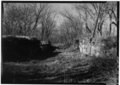 | 5,000 × 3,579 (17.07 MB) | commons>Bonnachoven | {{Information |Description ={{en|1=Looking upstream ("north") on the Broad Trunk Run Aqueduct, at 31.9 miles (just above Edwards Ferry) on the Chesapeake and Ohio Canal. This was originally a double culvert (44 1/2) converted to a wooden aqueduct, t... |
File usage
There are no pages that use this file.