Euren, Wisconsin
Jump to navigation
Jump to search
Euren, Wisconsin | |
|---|---|
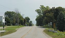
 Downtown Euren | |
| Coordinates: 44°37′06″N 87°36′08″W / 44.61833°N 87.60222°W | |
| Country | |
| State | |
| County | Kewaunee |
| Town | Lincoln |
| Elevation | 229 m (751 ft) |
| Time zone | UTC-6 (Central (CST)) |
| • Summer (DST) | UTC-5 (CDT) |
| Area code | 920 |
| GNIS feature ID | 1564713[1] |
Euren (pronounced like "urine")[2] is an unincorporated community in the town of Lincoln, Kewaunee County, Wisconsin, United States. It sits at the junction of County Highways C and S, 8 miles (13 km) west of Algoma.[3]
It has been noted on lists of unusual place names because of its pronunciation being similar to the word "urine".[4]

History
Euren Is an old German settlement located In northern Kewaunee County within the boundaries of the Town of Lincoin along County Trunk S between Algoma and Dyckesville. Pronounced Oy-ren, It was settled and named by early German setlers called Bottkols who named their new home after a small village in Germany.[5]
References
- ^ U.S. Geological Survey Geographic Names Information System: Euren, Wisconsin
- ^ MissPronouncer.com: A HALFWAY DECENT AUDIO PRONUNCIATION GUIDE FOR WISCONSIN
- ^ Kewaunee County (PDF) (Map). Wisconsin Department of Transportation. 2011. Archived from the original (PDF) on June 14, 2011. Retrieved 2011-09-12.
- ^ Parker, Quentin (2010). Welcome to Horneytown, North Carolina, Population: 15: An Insider's Guide to 201 of the World's Weirdest and Wildest Places. Adams Media. p. ix. ISBN 9781440507397.[permanent dead link]
- ^ Meet the Folks in Euren, Green Bay Press Gazette April 30 1975 Sec C-17
Categories:
- Pages using gadget WikiMiniAtlas
- All articles with dead external links
- Articles with dead external links from March 2024
- Articles with permanently dead external links
- Use mdy dates from February 2013
- Articles with short description
- Short description is different from Wikidata
- Coordinates on Wikidata
- Unincorporated communities in Kewaunee County, Wisconsin
- Unincorporated communities in Wisconsin
- All stub articles
- Green Bay metropolitan area geography stubs


