Arevis
Jump to navigation
Jump to search
Arevis
Արևիս | |
|---|---|
 | |
 Arevis  Arevis | |
| Coordinates: 39°24′18″N 45°54′04″E / 39.40500°N 45.90111°E | |
| Country | Armenia |
| Province | Syunik |
| Municipality | Sisian |
| Area | |
| • Total | 18.30 km2 (7.07 sq mi) |
| Population | |
| • Total | 54 |
| • Density | 3.0/km2 (7.6/sq mi) |
| Time zone | UTC+4 (AMT) |
| Arevis at GEOnet Names Server | |
Arevis (Armenian: Արևիս) is a village in the Sisian Municipality of the Syunik Province in Armenia.
Demographics
The Statistical Committee of Armenia reported its population as 140 in 2010,[3] up from 102 at the 2001 census.[4]
Gallery
-
 Tanahat church
 -
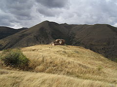
 Scenery
 -
 Tanahat church
 -
 Scenery
 -
 Tanahat church


References
Wikimedia Commons has media related to Arevis.
- ^ "Syunik regional e-Governance System" (in Armenian). Syunik Province provincial government. Click on link entitled "Համայնքներ" (community) and search for the place by Armenian name.
- ^ Statistical Committee of Armenia. "The results of the 2011 Population Census of Armenia" (PDF).
- ^ "Marzes of Armenia and Yerevan City in Figures, 2010" (PDF). Statistical Committee of Armenia.
- ^ Report of the results of the 2001 Armenian Census, Statistical Committee of Armenia

This article about a location in Syunik Province, Armenia is a stub. You can help Wikipedia by expanding it. |
Categories:
- Pages using gadget WikiMiniAtlas
- CS1 Armenian-language sources (hy)
- Articles with short description
- Short description is different from Wikidata
- Coordinates on Wikidata
- Articles containing Armenian-language text
- Commons category link from Wikidata
- Populated places in Syunik Province
- All stub articles
- Syunik geography stubs