File:The Arsenic Labyrinth at Botallack Mine - geograph.org.uk - 490315.jpg
Jump to navigation
Jump to search
No higher resolution available.
The_Arsenic_Labyrinth_at_Botallack_Mine_-_geograph.org.uk_-_490315.jpg (640 × 458 pixels, file size: 61 KB, MIME type: image/jpeg)
Summary
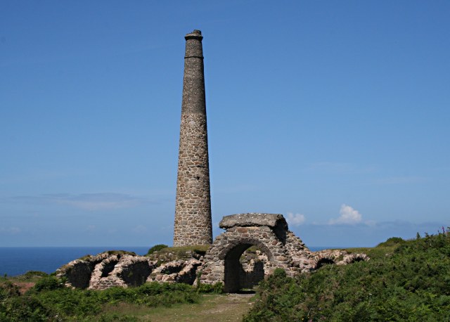
| Description |
English: The Arsenic Labyrinth at Botallack Mine Arsenic compounds were an unwanted pollutant in tin ore which ruined the smelting process. The solution was to heat the ore to drive off the arsenic as a vapour. In the early days of mining this badly polluted the surrounding countryside. However arsenic itself proved to be a saleable by-product so the arsenic fumes were sent through a labyrinth of tunnels where it would condense on the tunnel walls. This photo shows part of the arsenic labyrinth at Botallack mine. The maze of tunnels has partially collapsed. Half way through the labyrinth, the tunnel passes over the top of an arch to cross one of the entrances to the mine. At the end of the labyrinth the remaining fumes passed up the tall chimney shown in the photograph. |
| Date | |
| Source | From geograph.org.uk |
| Author | Tony Atkin |
| Attribution (required by the license) | Tony Atkin / The Arsenic Labyrinth at Botallack Mine / |
| Camera location | | View this and other nearby images on: OpenStreetMap |
|---|
_heading:292.00&language=en)
| Object location | | View this and other nearby images on: OpenStreetMap |
|---|
_heading:292.00&language=en)
Licensing

|
This image was taken from the Geograph project collection. See this photograph's page on the Geograph website for the photographer's contact details. The copyright on this image is owned by Tony Atkin and is licensed for reuse under the Creative Commons Attribution-ShareAlike 2.0 license.
|
This file is licensed under the Creative Commons Attribution-Share Alike 2.0 Generic license.
Attribution: Tony Atkin
- You are free:
- to share – to copy, distribute and transmit the work
- to remix – to adapt the work
- Under the following conditions:
- attribution – You must give appropriate credit, provide a link to the license, and indicate if changes were made. You may do so in any reasonable manner, but not in any way that suggests the licensor endorses you or your use.
- share alike – If you remix, transform, or build upon the material, you must distribute your contributions under the same or compatible license as the original.
File history
Click on a date/time to view the file as it appeared at that time.
| Date/Time | Thumbnail | Dimensions | User | Comment | |
|---|---|---|---|---|---|
| current | 06:15, 5 February 2011 | | 640 × 458 (61 KB) | commons>GeographBot | == {{int:filedesc}} == {{Information |description={{en|1=The Arsenic Labyrinth at Botallack Mine Arsenic compounds were an unwanted pollutant in tin ore which ruined the smelting process. The solution was to heat the ore to drive off the arsenic as a vap |
File usage
There are no pages that use this file.