File:VueVLSavion.jpg
Jump to navigation
Jump to search

Size of this preview: 800 × 533 pixels. Other resolutions: 320 × 213 pixels | 640 × 427 pixels | 1,024 × 683 pixels | 1,500 × 1,000 pixels.
Original file (1,500 × 1,000 pixels, file size: 442 KB, MIME type: image/jpeg)
Summary
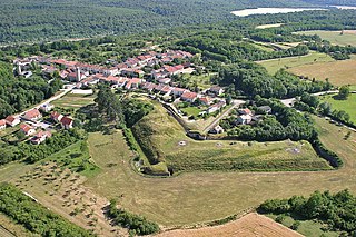
Vue de la batterie nord du fort de Villey-le-Sec
| Camera location | | View this and other nearby images on: OpenStreetMap |
|---|
Licensing
| I, the copyright holder of this work, release this work into the public domain. This applies worldwide. In some countries this may not be legally possible; if so: I grant anyone the right to use this work for any purpose, without any conditions, unless such conditions are required by law. |
File history
Click on a date/time to view the file as it appeared at that time.
| Date/Time | Thumbnail | Dimensions | User | Comment | |
|---|---|---|---|---|---|
| current | 22:03, 10 March 2007 | | 1,500 × 1,000 (442 KB) | commons>Citavls~commonswiki | Vue de la batterie nord du fort de Villey-le-Sec |
File usage
There are no pages that use this file.