File:Tuscarora trailhead marker 20201015 132147 1 crop.jpg
From WikiProjectMed
Jump to navigation
Jump to search
![File:Tuscarora trailhead marker 20201015 132147 1 crop.jpg](https://upload.wikimedia.org/wikipedia/commons/thumb/c/c2/Tuscarora_trailhead_marker_20201015_132147_1_crop.jpg/399px-Tuscarora_trailhead_marker_20201015_132147_1_crop.jpg)
Size of this preview: 399 × 599 pixels. Other resolutions: 160 × 240 pixels | 320 × 480 pixels | 512 × 768 pixels | 682 × 1,024 pixels | 1,365 × 2,048 pixels | 2,766 × 4,150 pixels.
Original file (2,766 × 4,150 pixels, file size: 7.34 MB, MIME type: image/jpeg)
This file is from a shared repository and may be used by other projects. The description on its file description page there is shown below.
Summary
DescriptionTuscarora trailhead marker 20201015 132147 1 crop.jpg |
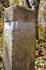
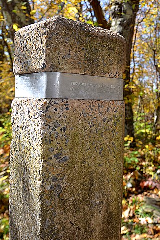
English: This unassuming concrete post marks the southern trail head of the Tuscarora trail. On the metal band is stamped "TUSCARORA / OVERALL RUN TR." with an arrow pointing to the right. |
Date | Taken on 15 October 2020, 13:21:47 |
Source | Own work |
Author | G. Edward Johnson |
keywords InfoField | trail, path, Tuscarora trail, concrete post, sign, marker, fall, autumn, yellow, leaves, terminus, trailhead |
Camera location | 38° 45′ 27.7″ N, 78° 17′ 11.19″ W ![]() | View this and other nearby images on: OpenStreetMap | ![]() |
---|
Licensing
I, the copyright holder of this work, hereby publish it under the following license:
![w:en:Creative Commons](https://upload.wikimedia.org/wikipedia/commons/thumb/7/79/CC_some_rights_reserved.svg/90px-CC_some_rights_reserved.svg.png)
![attribution](https://upload.wikimedia.org/wikipedia/commons/thumb/1/11/Cc-by_new_white.svg/24px-Cc-by_new_white.svg.png)
This file is licensed under the Creative Commons Attribution 3.0 Unported license.
- You are free:
- to share – to copy, distribute and transmit the work
- to remix – to adapt the work
- Under the following conditions:
- attribution – You must give appropriate credit, provide a link to the license, and indicate if changes were made. You may do so in any reasonable manner, but not in any way that suggests the licensor endorses you or your use.
Captions
Trail marker at the southern terminus of the Tuscarora Trail
Items portrayed in this file
depicts
some value
15 October 2020
38°45'27.702"N, 78°17'11.188"W
0.01666666666666666666 second
24 millimetre
400
image/jpeg
File history
Click on a date/time to view the file as it appeared at that time.
Date/Time | Thumbnail | Dimensions | User | Comment | |
---|---|---|---|---|---|
current | 23:04, 16 October 2020 | ![]() | 2,766 × 4,150 (7.34 MB) | commons>Lorax | Uploaded own work with UploadWizard |
File usage
There are no pages that use this file.
Metadata
This file contains additional information, probably added from the digital camera or scanner used to create or digitize it.
If the file has been modified from its original state, some details may not fully reflect the modified file.
Image title |
|
---|---|
Camera manufacturer | NIKON CORPORATION |
Camera model | NIKON D800 |
Copyright holder | Copyright 2020 G. Edward Johnson. CC-By |
Exposure time | 1/60 sec (0.016666666666667) |
F Number | f/8 |
ISO speed rating | 400 |
Date and time of data generation | 13:21, 15 October 2020 |
Lens focal length | 24 mm |
Latitude | 38° 45′ 27.7″ N |
Longitude | 78° 17′ 11.19″ W |
Altitude | 1,022.064 meters above sea level |
When re-using this work, please credit | G. Edward Johnson |
When re-using this work, please link to | http://edwardjohnson.com/ |
URL for copyright license | http://creativecommons.org/licenses/by/3.0/ |
Short title |
|
Credit/Provider | Copyright 2020 G. Edward Johnson. CC-By |
City shown | Shenandoah National Park |
Orientation | Normal |
Horizontal resolution | 300 dpi |
Vertical resolution | 300 dpi |
Software used | GIMP 2.8.16 |
File change date and time | 13:21, 15 October 2020 |
Y and C positioning | Co-sited |
Exposure Program | Aperture priority |
Exif version | 2.3 |
Date and time of digitizing | 13:21, 15 October 2020 |
Meaning of each component |
|
Image compression mode | 4 |
APEX exposure bias | 0 |
Maximum land aperture | 4 APEX (f/4) |
Metering mode | Center weighted average |
Light source | Unknown |
Flash | Flash fired, strobe return light detected, compulsory flash firing |
DateTime subseconds | 10 |
DateTimeOriginal subseconds | 10 |
DateTimeDigitized subseconds | 10 |
Supported Flashpix version | 1 |
Color space | sRGB |
Sensing method | One-chip color area sensor |
File source | Digital still camera |
Scene type | A directly photographed image |
Custom image processing | Normal process |
Exposure mode | Auto exposure |
White balance | Auto white balance |
Digital zoom ratio | 1 |
Focal length in 35 mm film | 24 mm |
Scene capture type | Standard |
Scene control | Low gain up |
Contrast | Normal |
Saturation | Normal |
Sharpness | Normal |
Subject distance range | Unknown |
GPS tag version | 2.3.0.0 |
Contact information | lorax@pobox.com
|
Keywords |
|
Copyright status | Copyrighted |
Code for country shown | US |
Province or state shown | VA |
Sublocation of city shown | Tuscarora Trailhead |
IIM version | 4 |