File:Tri-State Tornado trackmap (PAH).jpg
Jump to navigation
Jump to search
No higher resolution available.
Tri-State_Tornado_trackmap_(PAH).jpg (555 × 542 pixels, file size: 80 KB, MIME type: image/jpeg)
.jpg)
Summary
| Description |
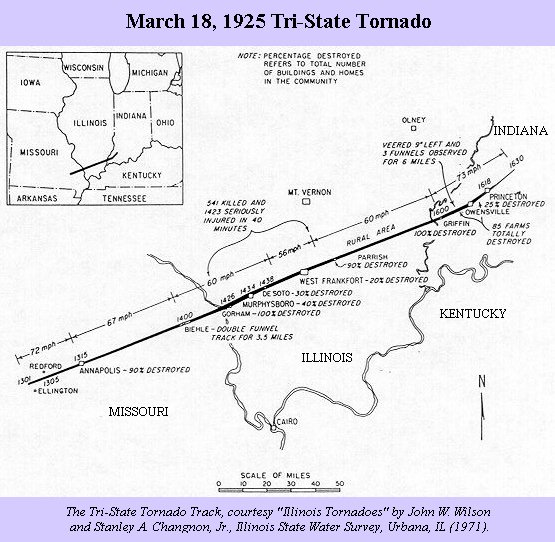
English: A map of the track of the 219-mile, 3.5 hour Tri-State Tornado which killed 695 in Missouri, Illinois, and Indiana on 18 March 1925. |
| Source | http://www.weather.gov/pah/1925Tornado_tt |
| Author | USGov-NOAA |
| Other versions | File:Tri-State Tornado trackmap cropped.png |
Licensing
This image is in the public domain because it contains materials that originally came from the U.S. National Oceanic and Atmospheric Administration, taken or made as part of an employee's official duties.
|
File history
Click on a date/time to view the file as it appeared at that time.
| Date/Time | Thumbnail | Dimensions | User | Comment | |
|---|---|---|---|---|---|
| current | 20:59, 13 November 2006 | | 555 × 542 (80 KB) | commons>Skyodyssey~commonswiki | A map of the track of the 219-mile, 3.5 hour Tri-State Tornado which killed 695 in Missouri, Illinois, and Indiana on 18 March 1925. http://www.crh.noaa.gov/pah/1925/tt_body.php Category:Tornadoes |
File usage
There are no pages that use this file.
.jpg)