File:Torii path with lantern at Fushimi Inari Taisha Shrine, Kyoto, Japan.jpg
From WikiProjectMed
Jump to navigation
Jump to search
![File:Torii path with lantern at Fushimi Inari Taisha Shrine, Kyoto, Japan.jpg](https://upload.wikimedia.org/wikipedia/commons/thumb/0/0e/Torii_path_with_lantern_at_Fushimi_Inari_Taisha_Shrine%2C_Kyoto%2C_Japan.jpg/800px-Torii_path_with_lantern_at_Fushimi_Inari_Taisha_Shrine%2C_Kyoto%2C_Japan.jpg)
Size of this preview: 800 × 533 pixels. Other resolutions: 320 × 213 pixels | 640 × 427 pixels | 1,024 × 683 pixels | 1,280 × 853 pixels | 2,560 × 1,707 pixels | 5,765 × 3,843 pixels.
Original file (5,765 × 3,843 pixels, file size: 8.71 MB, MIME type: image/jpeg)
This file is from a shared repository and may be used by other projects. The description on its file description page there is shown below.
Summary
DescriptionTorii path with lantern at Fushimi Inari Taisha Shrine, Kyoto, Japan.jpg |
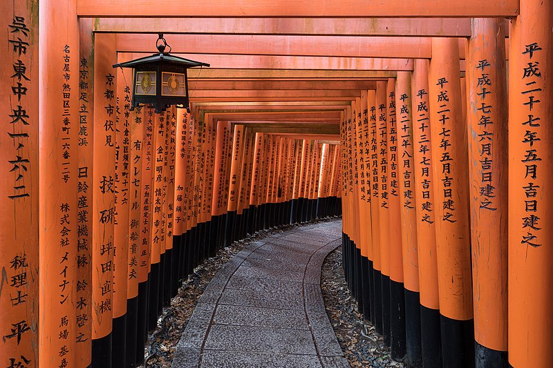
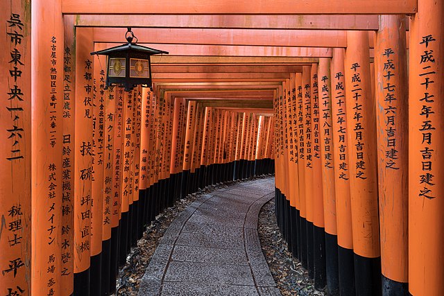
English: Torii path with a hanging lantern at Fushimi Inari Taisha Shrine Senbontorii, Kyoto, Japan.
Français : Couloir torii avec une lanterne suspendue au sanctuaire Senbontorii Fushimi Inari Taisha, Kyoto, Japon. |
Date | |
Source | Own work |
Author | Basile Morin |
Camera location | 34° 57′ 59.48″ N, 135° 46′ 30.8″ E ![]() | View this and other nearby images on: OpenStreetMap | ![]() |
---|
|
Licensing
I, the copyright holder of this work, hereby publish it under the following license:
![w:en:Creative Commons](https://upload.wikimedia.org/wikipedia/commons/thumb/7/79/CC_some_rights_reserved.svg/90px-CC_some_rights_reserved.svg.png)
![attribution](https://upload.wikimedia.org/wikipedia/commons/thumb/1/11/Cc-by_new_white.svg/24px-Cc-by_new_white.svg.png)
![share alike](https://upload.wikimedia.org/wikipedia/commons/thumb/d/df/Cc-sa_white.svg/24px-Cc-sa_white.svg.png)
This file is licensed under the Creative Commons Attribution-Share Alike 4.0 International license.
- You are free:
- to share – to copy, distribute and transmit the work
- to remix – to adapt the work
- Under the following conditions:
- attribution – You must give appropriate credit, provide a link to the license, and indicate if changes were made. You may do so in any reasonable manner, but not in any way that suggests the licensor endorses you or your use.
- share alike – If you remix, transform, or build upon the material, you must distribute your contributions under the same or compatible license as the original.
Captions
Torii path with lantern at Fushimi Inari Taisha Shrine, Kyoto, Japan
Items portrayed in this file
depicts
10 June 2019
34°57'59.483"N, 135°46'30.799"E
1.6 second
13
20 millimetre
image/jpeg
File history
Click on a date/time to view the file as it appeared at that time.
Date/Time | Thumbnail | Dimensions | User | Comment | |
---|---|---|---|---|---|
current | 15:55, 4 August 2019 | ![]() | 5,765 × 3,843 (8.71 MB) | commons>Basile Morin | User created page with UploadWizard |
File usage
There are no pages that use this file.
Metadata
This file contains additional information, probably added from the digital camera or scanner used to create or digitize it.
If the file has been modified from its original state, some details may not fully reflect the modified file.
Camera manufacturer | Canon |
---|---|
Camera model | Canon EOS 5D Mark IV |
Author | Basile Morin |
Copyright holder |
|
Exposure time | 8/5 sec (1.6) |
F Number | f/13 |
ISO speed rating | 50 |
Date and time of data generation | 05:37, 10 June 2019 |
Lens focal length | 20 mm |
Latitude | 34° 57′ 59.48″ N |
Longitude | 135° 46′ 30.8″ E |
Altitude | 4.6 meters above sea level |
Horizontal resolution | 238 dpi |
Vertical resolution | 238 dpi |
Software used | Adobe Photoshop Lightroom 6.12 (Windows) |
File change date and time | 14:28, 6 July 2019 |
Exposure Program | Manual |
Exif version | 2.3 |
Date and time of digitizing | 05:37, 10 June 2019 |
APEX shutter speed | −0.678072 |
APEX aperture | 7.400879 |
APEX exposure bias | 0 |
Maximum land aperture | 4 APEX (f/4) |
Metering mode | Pattern |
Flash | Flash did not fire, compulsory flash suppression |
DateTimeOriginal subseconds | 23 |
DateTimeDigitized subseconds | 23 |
Color space | sRGB |
Focal plane X resolution | 1,866.6666564941 |
Focal plane Y resolution | 1,866.6666564941 |
Focal plane resolution unit | 3 |
Custom image processing | Normal process |
Exposure mode | Manual exposure |
White balance | Auto white balance |
Scene capture type | Standard |
GPS time (atomic clock) | 22:33:11.173 |
Satellites used for measurement | 7 |
Receiver status | Measurement in progress |
Measurement mode | 3-dimensional measurement |
Measurement precision | Good (2.1) |
Geodetic survey data used | WGS-84 |
GPS date | 9 June 2019 |
GPS tag version | 0.0.3.2 |
Serial number of camera | 088053003158 |
Lens used | EF11-24mm f/4L USM |
Date metadata was last modified | 21:28, 6 July 2019 |
Unique ID of original document | 82D565EDF7288C82F080CC9100E1538C |
Copyright status | Copyrighted |
IIM version | 4 |