File:Syrian Civil War map (March 15 2012).svg
Jump to navigation
Jump to search

Size of this PNG preview of this SVG file: 725 × 599 pixels. Other resolutions: 290 × 240 pixels | 581 × 480 pixels | 929 × 768 pixels | 1,239 × 1,024 pixels | 2,478 × 2,048 pixels | 922 × 762 pixels.
Original file (SVG file, nominally 922 × 762 pixels, file size: 8.44 MB)
.svg)
Summary
| Description |
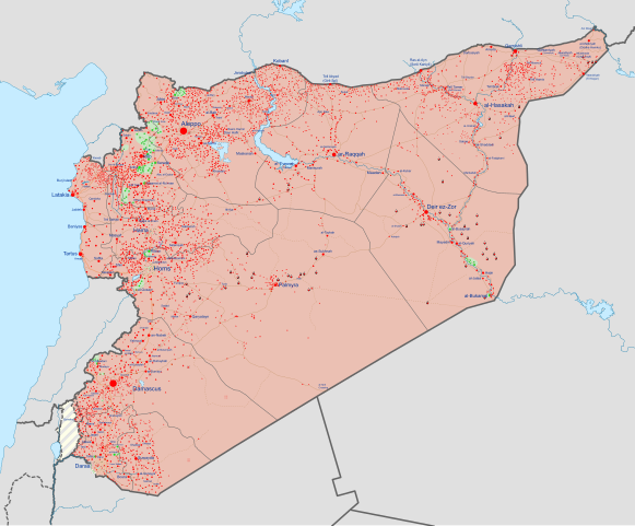
English: Detailed map of Syria showing the approximate frontlines during mid-March 2012; inspired by Ermanarich's work. All credit goes to Cedric Labrousse's work (https://twitter.com/syria_rebel_obs).
In the respective colours: |
||
| Date | |||
| Source |
Own work
|
||
| Author | Rr016 |
Licensing
I, the copyright holder of this work, hereby publish it under the following license:
This file is licensed under the Creative Commons Attribution-Share Alike 4.0 International license.
- You are free:
- to share – to copy, distribute and transmit the work
- to remix – to adapt the work
- Under the following conditions:
- attribution – You must give appropriate credit, provide a link to the license, and indicate if changes were made. You may do so in any reasonable manner, but not in any way that suggests the licensor endorses you or your use.
- share alike – If you remix, transform, or build upon the material, you must distribute your contributions under the same or compatible license as the original.
File history
Click on a date/time to view the file as it appeared at that time.
| Date/Time | Thumbnail | Dimensions | User | Comment | |
|---|---|---|---|---|---|
| current | 13:05, 12 September 2019 | | 922 × 762 (8.44 MB) | commons>Rr016 | Correction: Shuaytat tribe villages (Deir Ez Zor) was under FSA control since February 2012 according to Syrian Rebellion Observatory |
File usage
There are no pages that use this file.
.svg)