File:State of Cuman-Kipchak (13.) tr.png
Jump to navigation
Jump to search

Size of this preview: 800 × 501 pixels. Other resolutions: 320 × 200 pixels | 640 × 401 pixels | 1,024 × 641 pixels | 1,280 × 801 pixels | 2,326 × 1,456 pixels.
Original file (2,326 × 1,456 pixels, file size: 548 KB, MIME type: image/png)
Summary
| Description |
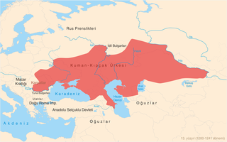
Türkçe: 13. yüzyılda (1200-1241 dönemi) Kuman-Kıpçak ülkesi haritası. Bugünkü (2011) devlet sınırları da belirtilmiştir. English: Map of State of Cuman-Kipchaks in the 13th Century (1200-1241 period) in Turkish with todays (2011) borders.
Harita Kaynakları: Asıl Kaynak:
Ek Kaynaklar:
|
| Date | |
| Source | Own work |
| Author | Photo Balkan |
| Other versions |
[]
|


_en.png)

_tr.png)
_tr.png)
Licensing
I, the copyright holder of this work, hereby publish it under the following license:
This file is licensed under the Creative Commons Attribution-Share Alike 3.0 Unported license.
- You are free:
- to share – to copy, distribute and transmit the work
- to remix – to adapt the work
- Under the following conditions:
- attribution – You must give appropriate credit, provide a link to the license, and indicate if changes were made. You may do so in any reasonable manner, but not in any way that suggests the licensor endorses you or your use.
- share alike – If you remix, transform, or build upon the material, you must distribute your contributions under the same or compatible license as the original.
File history
Click on a date/time to view the file as it appeared at that time.
| Date/Time | Thumbnail | Dimensions | User | Comment | |
|---|---|---|---|---|---|
| current | 15:43, 16 November 2022 | | 2,326 × 1,456 (548 KB) | commons>Gyalu22 | Reverted to version as of 12:01, 24 October 2011 (UTC) |
File usage
There are no pages that use this file.
_tr.png)