File:Spanish City, Whitley Bay (geograph 7492725).jpg
Jump to navigation
Jump to search

Size of this preview: 800 × 600 pixels. Other resolutions: 320 × 240 pixels | 640 × 480 pixels | 1,024 × 768 pixels | 1,280 × 960 pixels | 1,600 × 1,200 pixels.
Original file (1,600 × 1,200 pixels, file size: 843 KB, MIME type: image/jpeg)
.jpg)
Summary
| Description |
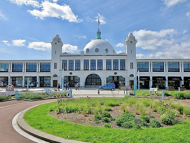
English: This iconic Grade II Listed building, variously known as the Spanish City, the Rotunda and The Dome, recently underwent substantial renovation and reopened to the public in the summer of 2018. It now houses a number of eating facilities. |
| Date | |
| Source | From geograph.org.uk |
| Author | Geoff Holland |
| Permission (Reusing this file) |
Creative Commons Attribution Share-alike license 2.0 |
| Attribution (required by the license) | Geoff Holland / Spanish City, Whitley Bay / |
| Camera location | | View this and other nearby images on: OpenStreetMap |
|---|
.jpg¶ms=055.047905_N_-001.447491_E_globe:Earth_type:camera_source:geograph-osgb36(NZ35407274)_heading:180.00&language=en)
| Object location | | View this and other nearby images on: OpenStreetMap |
|---|
.jpg¶ms=055.047640_N_-001.447490_E_globe:Earth_class:object_type:object_source:geograph-osgb36(NZ35407271)_heading:180.00&language=en)
Licensing

|
This image was taken from the Geograph project collection. See this photograph's page on the Geograph website for the photographer's contact details. The copyright on this image is owned by Geoff Holland and is licensed for reuse under the Creative Commons Attribution-ShareAlike 2.0 license.
|
This file is licensed under the Creative Commons Attribution-Share Alike 2.0 Generic license.
Attribution: Geoff Holland
- You are free:
- to share – to copy, distribute and transmit the work
- to remix – to adapt the work
- Under the following conditions:
- attribution – You must give appropriate credit, provide a link to the license, and indicate if changes were made. You may do so in any reasonable manner, but not in any way that suggests the licensor endorses you or your use.
- share alike – If you remix, transform, or build upon the material, you must distribute your contributions under the same or compatible license as the original.
File history
Click on a date/time to view the file as it appeared at that time.
| Date/Time | Thumbnail | Dimensions | User | Comment | |
|---|---|---|---|---|---|
| current | 11:21, 13 October 2023 | | 1,600 × 1,200 (843 KB) | commons>Chocolateediter | Lighter |
File usage
There are no pages that use this file.
.jpg)