File:Shelling of Newcastle naval intelligence map.jpg
Jump to navigation
Jump to search

Size of this preview: 725 × 599 pixels. Other resolutions: 290 × 240 pixels | 581 × 480 pixels | 963 × 796 pixels.
Original file (963 × 796 pixels, file size: 72 KB, MIME type: image/jpeg)
Summary
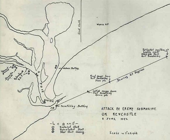
| Description | Royal Australian Navy naval intelligence map depicting the Japanese submarine I-21's attack on the Australian city of Newcastle in the early hours of 8 June 1942 |
| Date | |
| Source | National Archives of Australia file B6121, page 64 http://recordsearch.naa.gov.au/SearchNRetrieve/Interface/DetailsReports/ItemDetail.aspx?Barcode=399548 |
| Author | Royal Australian Navy |
| Permission (Reusing this file) |
Due to its age the copyright will have expired on this Australian Government document |
Licensing
This image is protected by Crown Copyright because it is owned by the Australian Government or that of the states or territories, and is in the public domain because it was created or published prior to 1974 and the copyright has therefore expired. The government of Australia has declared that the expiration of Crown Copyrights applies worldwide. This has been confirmed by correspondence received by the Volunteer Response Team (Ticket:2017062010010417).
|
 |
File history
Click on a date/time to view the file as it appeared at that time.
| Date/Time | Thumbnail | Dimensions | User | Comment | |
|---|---|---|---|---|---|
| current | 12:06, 25 June 2011 | | 963 × 796 (72 KB) | commons>Nick-D | Fix metadata (hopefully) |
File usage
There are no pages that use this file.