File:Sefton UK locator map.svg
Jump to navigation
Jump to search

Size of this PNG preview of this SVG file: 565 × 599 pixels. Other resolutions: 226 × 240 pixels | 453 × 480 pixels | 724 × 768 pixels | 966 × 1,024 pixels | 1,932 × 2,048 pixels | 1,231 × 1,305 pixels.
Original file (SVG file, nominally 1,231 × 1,305 pixels, file size: 782 KB)
| Description |
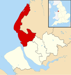
Map of Merseyside, UK with Sefton highlighted. Equirectangular map projection on WGS 84 datum, with N/S stretched 165% |
| Date | |
| Source | Ordnance Survey OpenData. Most data from Boundary-Line product. Lake data from Meridian 2 product. Inset derived from England location map.svg by Spischot. |
| Author | Nilfanion, created using Ordnance Survey data |
| Permission (Reusing this file) |
This file is licensed under the Creative Commons Attribution-Share Alike 3.0 Unported license. Attribution: Contains Ordnance Survey data © Crown copyright and database right
|
File history
Click on a date/time to view the file as it appeared at that time.
| Date/Time | Thumbnail | Dimensions | User | Comment | |
|---|---|---|---|---|---|
| current | 20:15, 1 September 2013 | | 1,231 × 1,305 (782 KB) | commons>Nilfanion | {{Information |Description=Map of Merseyside, UK with Sefton highlighted. Equirectangular map projection on WGS 84 datum, with N/S stretched 165% |Source=Ordnance Survey [https://www.ordnancesurvey.co.uk/opendata... |
File usage
There are no pages that use this file.