File:Prerow strom.jpg
Jump to navigation
Jump to search

Size of this preview: 800 × 551 pixels. Other resolutions: 320 × 220 pixels | 640 × 441 pixels | 1,024 × 705 pixels | 1,280 × 882 pixels | 2,186 × 1,506 pixels.
Original file (2,186 × 1,506 pixels, file size: 405 KB, MIME type: image/jpeg)
Summary
| Description |
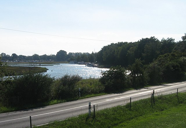
English: A small section of the Prerow Channel which once completely separated the former island of Darß from the former island of of Zingst, seen from the state road (L) 21 NE of the town of Prerow, with the small Prerow harbour in the background, Western Pomerania, East German Baltic Sea coastal area.
Deutsch: Ein kleiner Abschnitt des nördlichen Teils des Prerower Stroms zwischen Zingst und Darß, gesehen von der L21 nordöstlich von Prerow, mit dem Prerower Hafen im Hintergrund.
|
| Date | 22 August 2006 (according to Exif data) |
| Source | No machine-readable source provided. Own work assumed (based on copyright claims). |
| Author | No machine-readable author provided. Alma assumed (based on copyright claims). |
| Camera location | | View this and other nearby images on: OpenStreetMap |
|---|
Liensing
Licensing
I, the copyright holder of this work, hereby publish it under the following license:
This file is licensed under the Creative Commons Attribution-Share Alike 2.5 Generic license.
- You are free:
- to share – to copy, distribute and transmit the work
- to remix – to adapt the work
- Under the following conditions:
- attribution – You must give appropriate credit, provide a link to the license, and indicate if changes were made. You may do so in any reasonable manner, but not in any way that suggests the licensor endorses you or your use.
- share alike – If you remix, transform, or build upon the material, you must distribute your contributions under the same or compatible license as the original.
File history
Click on a date/time to view the file as it appeared at that time.
| Date/Time | Thumbnail | Dimensions | User | Comment | |
|---|---|---|---|---|---|
| current | 12:40, 9 November 2007 | | 2,186 × 1,506 (405 KB) | commons>Prolineserver | rotated |
File usage
There are no pages that use this file.