File:PIA00217.jpg
Jump to navigation
Jump to search

Size of this preview: 680 × 600 pixels. Other resolutions: 272 × 240 pixels | 544 × 480 pixels | 871 × 768 pixels | 1,161 × 1,024 pixels | 2,323 × 2,048 pixels | 8,131 × 7,169 pixels.
Original file (8,131 × 7,169 pixels, file size: 9.02 MB, MIME type: image/jpeg)
File history
Click on a date/time to view the file as it appeared at that time.
| Date/Time | Thumbnail | Dimensions | User | Comment | |
|---|---|---|---|---|---|
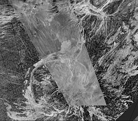
| current | 10:02, 5 May 2024 | | 8,131 × 7,169 (9.02 MB) | commons>PlanetUser | {{Information |Description={{en|This composite image was created by inserting approximately 70 orbits of Magellan data into an image obtained at the Arecibo, Puerto Rico radiotelescope and shows a geologically complex region in the southern hemisphere of Venus. The region is centered on 65 degrees south, 359 degrees east and is about 1500 x 1500 km (900 x 900 miles) in extent. The large oval feature in the lower half of the image is Quetzalpetlatl Corona, approximately 700 km (420 miles) in d... |
File usage
There are no pages that use this file.