File:P&WV map.svg
Jump to navigation
Jump to search

Size of this PNG preview of this SVG file: 414 × 213 pixels. Other resolutions: 320 × 165 pixels | 640 × 329 pixels | 1,024 × 527 pixels | 1,280 × 659 pixels | 2,560 × 1,317 pixels.
Original file (SVG file, nominally 414 × 213 pixels, file size: 27 KB)
File history
Click on a date/time to view the file as it appeared at that time.
| Date/Time | Thumbnail | Dimensions | User | Comment | |
|---|---|---|---|---|---|
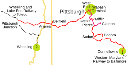
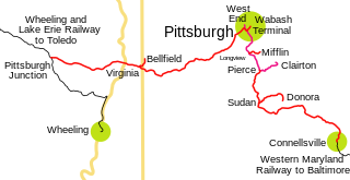
| current | 23:05, 5 October 2005 | | 414 × 213 (27 KB) | commons>SPUI~commonswiki | {{spuimap}} Pittsburgh and West Virginia Railway traced on USGS topos. Category:Norfolk and Western Railway Category:Railroad maps |
File usage
There are no pages that use this file.