File:Nevis Aerial.jpg
Jump to navigation
Jump to search
No higher resolution available.
Nevis_Aerial.jpg (500 × 306 pixels, file size: 51 KB, MIME type: image/jpeg)
Summary
| Description |
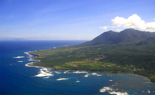
English: Aerial shot taken from the northeast, depicting the east coast of the island of Nevis, Saint James Windward Parish, Saint Kitts and Nevis, West Indies. Long Haul Bay in the foreground. The islands of Redonda and Montserrat are visible at the horizon. |
| Date | |
| Source | Own work |
| Author | Aaron Vos |
Licensing
This file is licensed under the Creative Commons Attribution-Share Alike 2.5 Generic license.
Attribution: Aaron Vos
- You are free:
- to share – to copy, distribute and transmit the work
- to remix – to adapt the work
- Under the following conditions:
- attribution – You must give appropriate credit, provide a link to the license, and indicate if changes were made. You may do so in any reasonable manner, but not in any way that suggests the licensor endorses you or your use.
- share alike – If you remix, transform, or build upon the material, you must distribute your contributions under the same or compatible license as the original.
Original upload log
All following user names refer to en.wikipedia.
- 2006-06-09 07:01 Pia L 500×306× (51 KB) (Attribution: Photo by Aaron Vos {{Cc-by-sa-2.5|Attribution details.}} Subject: Aerial shot depicting the southeast coast of the island of Nevis, Saint James Windward Parish, Nevis, West Indies. Date: 27 December 2005. Original digital photograph, uploaded)
File history
Click on a date/time to view the file as it appeared at that time.
| Date/Time | Thumbnail | Dimensions | User | Comment | |
|---|---|---|---|---|---|
| current | 11:05, 16 February 2011 | | 500 × 306 (51 KB) | commons>Telim tor | == {{int:filedesc}} == {{Information |Description={{en|Aerial shot taken from the northeast, depicting the east coast of the island of Nevis, Saint James Windward Parish, Saint Kitts and Nevis, West Indies. Long Haul Bay in the foreground. The islands of |
File usage
There are no pages that use this file.