File:Map of British plantations of Ireland, 1550–1610.png
Jump to navigation
Jump to search

No higher resolution available.
Map_of_British_plantations_of_Ireland,_1550–1610.png (466 × 565 pixels, file size: 7 KB, MIME type: image/png)
Summary
| Description |
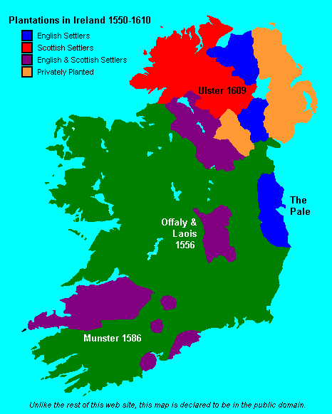
English: Map showing the major British crown-organised and private-sector "plantations" (colonies) in Ireland from ca. 1550 to 1610. Colour-coded as to Scottish, English or a mixture (other than it is not clear that the privately organized plantations in Ulster varied in composition, but heavy toward the Scots side). This file is supplied as requested PNG replacement for an undesirable GIF, though the entire thing would be better redone as an SVG. |
| Date | (original 2007-05-09) |
| Source | Proximally, from GIF version; ultimately, from http://www.wesleyjohnston.com/users/ireland/maps/historical/map1609.gif |
| Author | www.wesleyjohnston.com |
| Permission (Reusing this file) |
Public domain by declaration of original creator (see notice at bottom of original GIF-format upload) |
| Other versions |
|

Licensing
License declared by original uploader User:NielsF:
| I, the copyright holder of this work, release this work into the public domain. This applies worldwide. In some countries this may not be legally possible; if so: I grant anyone the right to use this work for any purpose, without any conditions, unless such conditions are required by law. |
File history
Click on a date/time to view the file as it appeared at that time.
| Date/Time | Thumbnail | Dimensions | User | Comment | |
|---|---|---|---|---|---|
| current | 17:04, 8 June 2024 | | 466 × 565 (7 KB) | commons>SMcCandlish | {{Information |Description={{en|Map showing the major British crown-organised and private-sector "plantations" (colonies) in Ireland from ca. 1550 to 1610. Colour-coded as to Scottish, English or a mixture (other than it is not clear that the privately organized plantation varied in composition; the one in Ulster predominantly Scots settlers, the more southerly ones predominantly English). This file is supplied as requested PNG replacement for an undesirable GIF, though the entire thing would... |
File usage
There are no pages that use this file.