File:Llynwernog Lead and Silver Mine (geograph 3391527).jpg
Jump to navigation
Jump to search
No higher resolution available.
Llynwernog_Lead_and_Silver_Mine_(geograph_3391527).jpg (640 × 424 pixels, file size: 284 KB, MIME type: image/jpeg)
.jpg)
Summary
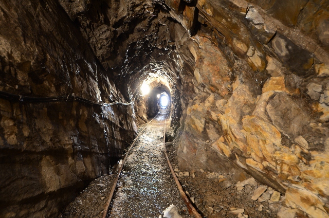
| Description |
English: Llynwernog Lead and Silver Mine. Silver (Ag) has a similar ionic radius to lead (Pb) so silver/lead mines are common. Especially in the Northern Pennines. This is an exploration adit driven in 1906 to hit the galena (PbS) bearing vein. It was a failed venture. |
| Date | |
| Source | From geograph.org.uk |
| Author | Ashley Dace |
| Permission (Reusing this file) |
Creative Commons Attribution Share-alike license 2.0 |
| Attribution (required by the license) | Ashley Dace / Llynwernog Lead and Silver Mine / |
| Object location | | View this and other nearby images on: OpenStreetMap |
|---|
.jpg¶ms=052.411720_N_-003.865490_E_globe:Earth_class:object_type:object_source:geograph-osgb36(SN73218094)_&language=en)
Licensing

|
This image was taken from the Geograph project collection. See this photograph's page on the Geograph website for the photographer's contact details. The copyright on this image is owned by Ashley Dace and is licensed for reuse under the Creative Commons Attribution-ShareAlike 2.0 license.
|
This file is licensed under the Creative Commons Attribution-Share Alike 2.0 Generic license.
Attribution: Ashley Dace
- You are free:
- to share – to copy, distribute and transmit the work
- to remix – to adapt the work
- Under the following conditions:
- attribution – You must give appropriate credit, provide a link to the license, and indicate if changes were made. You may do so in any reasonable manner, but not in any way that suggests the licensor endorses you or your use.
- share alike – If you remix, transform, or build upon the material, you must distribute your contributions under the same or compatible license as the original.
File history
Click on a date/time to view the file as it appeared at that time.
| Date/Time | Thumbnail | Dimensions | User | Comment | |
|---|---|---|---|---|---|
| current | 15:26, 4 April 2018 | | 640 × 424 (284 KB) | commons>Chris j wood | Transferred from geograph.co.uk using [https://tools.wmflabs.org/geograph2commons/ geograph2commons] |
File usage
There are no pages that use this file.
.jpg)