File:Livingston-Island-Map-2010.jpg
Jump to navigation
Jump to search

Size of this preview: 800 × 555 pixels. Other resolutions: 320 × 222 pixels | 640 × 444 pixels | 1,024 × 710 pixels | 1,280 × 888 pixels | 2,560 × 1,776 pixels | 5,027 × 3,487 pixels.
Original file (5,027 × 3,487 pixels, file size: 7.07 MB, MIME type: image/jpeg)
Summary
| Description |
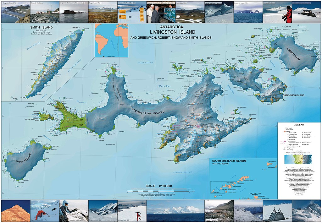
English: L.L. Ivanov. Antarctica: Livingston Island and Greenwich, Robert, Snow and Smith Islands. Scale 1:120000 topographic map. Troyan: Manfred Wörner Foundation, 2010. ISBN 978-954-92032-9-5 (First edition 2009. ISBN 978-954-92032-6-4) |
| Date | |
| Source | Own work |
| Author | Apcbg |
| Permission (Reusing this file) |
Licensing
I, the copyright holder of this work, hereby publish it under the following license:
This file is licensed under the Creative Commons Attribution-Share Alike 4.0 International license.
- You are free:
- to share – to copy, distribute and transmit the work
- to remix – to adapt the work
- Under the following conditions:
- attribution – You must give appropriate credit, provide a link to the license, and indicate if changes were made. You may do so in any reasonable manner, but not in any way that suggests the licensor endorses you or your use.
- share alike – If you remix, transform, or build upon the material, you must distribute your contributions under the same or compatible license as the original.
Published by the Manfred Wörner Foundation, and hereby released by the Foundation’s President and CEO Apcbg (Lyubomir Ivanov) for publication under the Creative Commons Attribution ShareAlike 4.0 license.
File history
Click on a date/time to view the file as it appeared at that time.
| Date/Time | Thumbnail | Dimensions | User | Comment | |
|---|---|---|---|---|---|
| current | 04:46, 29 June 2015 | | 5,027 × 3,487 (7.07 MB) | commons>Apcbg | {{Information |Description ={{en|1= L.L. Ivanov. Antarctica: Livingston Island and Greenwich, Robert, Snow and Smith Islands. Scale 1:120000 topographic map. Troyan: Manfred Wörner Foundation, 2010. ISBN 978-954-92032-9-5 (First edition 2009. ISBN... |
File usage
There are no pages that use this file.