File:Lebak Tsunami.jpg
Jump to navigation
Jump to search

Size of this preview: 629 × 599 pixels. Other resolutions: 252 × 240 pixels | 504 × 480 pixels | 806 × 768 pixels | 1,075 × 1,024 pixels | 2,150 × 2,048 pixels | 3,823 × 3,642 pixels.
Original file (3,823 × 3,642 pixels, file size: 3.54 MB, MIME type: image/jpeg)
Summary
| Description |
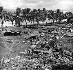
English: Tsunami disaster at barangay Tibpuan - Tsunami damage at Lebak, caused by the earthquake of magnitude (Ms)= 7.9, in Moro Gulf. Island of Mindanao, Philippines. August 16, 1976. [Earthquake occurred August 16, 1976, centered at 6.3 degrees north and 124.0 degrees east. The earthquake killed about 8,000 people] Published on back cover of U.S. Geological Survey. Earthquake Information Bulletin. v. 14. no. 4. July-August 1982. |
| Date | |
| Source |
http://libraryphoto.cr.usgs.gov/cgi-bin/show_picture.cgi?ID=ID.%20Wallace,%20R.E.%20%20313&SIZE=medium U.S. Geological Survey Photographic Library |
| Author | Wallace, R.E. 313 |
Licensing
This image is in the public domain in the United States because it only contains materials that originally came from the United States Geological Survey, an agency of the United States Department of the Interior. For more information, see the official USGS copyright policy.
|
File history
Click on a date/time to view the file as it appeared at that time.
| Date/Time | Thumbnail | Dimensions | User | Comment | |
|---|---|---|---|---|---|
| current | 11:42, 29 July 2011 | | 3,823 × 3,642 (3.54 MB) | commons>Bonvallite |
File usage
There are no pages that use this file.