File:Last Island Map4.JPG
Jump to navigation
Jump to search

Size of this preview: 705 × 600 pixels. Other resolutions: 282 × 240 pixels | 564 × 480 pixels | 1,000 × 851 pixels.
Original file (1,000 × 851 pixels, file size: 132 KB, MIME type: image/jpeg)
File history
Click on a date/time to view the file as it appeared at that time.
| Date/Time | Thumbnail | Dimensions | User | Comment | |
|---|---|---|---|---|---|
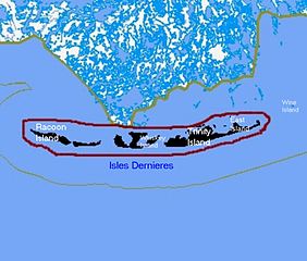
| current | 01:52, 27 August 2010 | | 1,000 × 851 (132 KB) | commons>Lynntoniolondon | {{Information |Description=Map of remaining portions of Last Island, Louisiana |Source=Map drawn by User:sf46 based on information gathered from U.S. Federal Government website: [http://www.census.gov census.gov] |Date=6/26/2009 |Author=[[User:sf4 |
File usage
There are no pages that use this file.