File:Lake Shala.jpg
Jump to navigation
Jump to search

Size of this preview: 800 × 600 pixels. Other resolutions: 320 × 240 pixels | 640 × 480 pixels | 1,024 × 768 pixels.
Original file (1,024 × 768 pixels, file size: 144 KB, MIME type: image/jpeg)
Summary
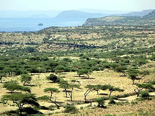
| Description | Lake Shala lies in a collapsed volcanic caldera 265 meters deep. Ethiopia's Rift Valley is part of a 4,000-kilometer fissure stretching from Syria to Mozambique. Acacia trees dot the landscape. |
| Date | |
| Source | Lake Shala |
| Author | David Stanley from Nanaimo, Canada |
| Camera location | | View this and other nearby images on: OpenStreetMap |
|---|
Licensing
This file is licensed under the Creative Commons Attribution 2.0 Generic license.
- You are free:
- to share – to copy, distribute and transmit the work
- to remix – to adapt the work
- Under the following conditions:
- attribution – You must give appropriate credit, provide a link to the license, and indicate if changes were made. You may do so in any reasonable manner, but not in any way that suggests the licensor endorses you or your use.
| This image was originally posted to Flickr by D-Stanley at https://flickr.com/photos/79721788@N00/11414992265. It was reviewed on 25 October 2017 by FlickreviewR and was confirmed to be licensed under the terms of the cc-by-2.0. |
File history
Click on a date/time to view the file as it appeared at that time.
| Date/Time | Thumbnail | Dimensions | User | Comment | |
|---|---|---|---|---|---|
| current | 15:53, 25 October 2017 | | 1,024 × 768 (144 KB) | commons>LittleT889 | =={{int:filedesc}}== {{Information |Description=Lake Shala lies in a collapsed volcanic caldera 265 meters deep. Ethiopia's Rift Valley is part of a 4,000-kilometer fissure stretching from Syria to Mozambique. Acacia trees dot the landscape. |Source=[h... |
File usage
There are no pages that use this file.