File:Köcherbaumwald-01.jpg
Jump to navigation
Jump to search

Size of this preview: 800 × 531 pixels. Other resolutions: 320 × 213 pixels | 640 × 425 pixels | 1,024 × 680 pixels | 1,280 × 850 pixels | 2,560 × 1,700 pixels | 4,288 × 2,848 pixels.
Original file (4,288 × 2,848 pixels, file size: 10.3 MB, MIME type: image/jpeg)
Summary
| Photographer | |
| Description |
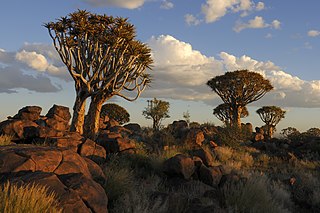
Afrikaans: Skemerlig op die Kokerboomwoud oos van Keetmanshoop, Namibië
English: Quiver Tree Forest near Keetmanshoop, Namibia, in the evening
Deutsch: Köcherbaumwald bei Keetmanshoop, Namibia - Abendstimmung.
Français : La forêt de Kokerboom le soir, près de la ville de Keetmanshoop dans région de Karas, au sud de la Namibie. |
| Place of discovery | English: Karas Region, southern Namibia
Français : région de Karas, au sud de la Namibie |
| Date | 18 April 2012, 17:11:25 |
| Source | Own work |
| Camera location | | View this and other nearby images on: OpenStreetMap |
|---|
Assessment
|
This image was selected as picture of the day on Wikimedia Commons for 22 April 2013. It was captioned as follows: Other languages:
Français : La forêt de Kokerboom au sud de la Namibie. Magyar: Aloéfák (Aloë dichotoma – ágastörzsű aloé) napnyugtakor a róluk elnevezett Quiver Tree Forestben (Kokerboomwoud vagy Köcherbaumwald), Keetmanshoop városához közel (Karas régió, Dél-Namíbia) Русский: Лес колчановых деревьев недалеко от Китмансхупа, Намибия. 中文: 纳米比亚箭筒树森林。 |
Licensing
I, the copyright holder of this work, hereby publish it under the following license:
This file is licensed under the Creative Commons Attribution-Share Alike 3.0 Unported license.
- You are free:
- to share – to copy, distribute and transmit the work
- to remix – to adapt the work
- Under the following conditions:
- attribution – You must give appropriate credit, provide a link to the license, and indicate if changes were made. You may do so in any reasonable manner, but not in any way that suggests the licensor endorses you or your use.
- share alike – If you remix, transform, or build upon the material, you must distribute your contributions under the same or compatible license as the original.
File history
Click on a date/time to view the file as it appeared at that time.
| Date/Time | Thumbnail | Dimensions | User | Comment | |
|---|---|---|---|---|---|
| current | 18:43, 7 January 2013 | | 4,288 × 2,848 (10.3 MB) | commons>Iifar | Reduced noise level on the sky |
File usage
There are no pages that use this file.