File:Flores Locator Topography.png
Jump to navigation
Jump to search

Size of this preview: 800 × 473 pixels. Other resolutions: 320 × 189 pixels | 640 × 379 pixels | 1,024 × 606 pixels | 1,280 × 757 pixels | 2,559 × 1,514 pixels.
Original file (2,559 × 1,514 pixels, file size: 1.46 MB, MIME type: image/png)
File history
Click on a date/time to view the file as it appeared at that time.
| Date/Time | Thumbnail | Dimensions | User | Comment | |
|---|---|---|---|---|---|
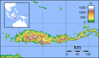
| current | 04:20, 1 February 2010 | | 2,559 × 1,514 (1.46 MB) | commons>Elekhh | {{Information |Description=Topographic map of Flores, Indonesia. Created with GMT from SRTM data. |Source=*File:Flores_Topography.png |Date=2010-02-01 04:17 (UTC) |Author=*File:Flores_Topography.png: Sadalmelik *derivative |
File usage
There are no pages that use this file.