File:Eva-archaic-site-profile-tn1.jpg
Jump to navigation
Jump to search
No higher resolution available.
Eva-archaic-site-profile-tn1.jpg (421 × 234 pixels, file size: 15 KB, MIME type: image/jpeg)
File history
Click on a date/time to view the file as it appeared at that time.
| Date/Time | Thumbnail | Dimensions | User | Comment | |
|---|---|---|---|---|---|
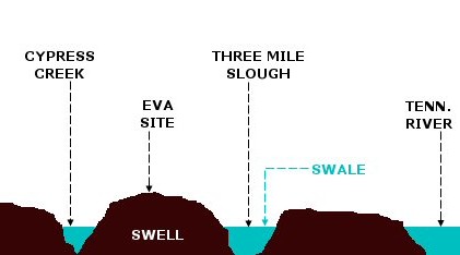
| current | 20:56, 17 March 2008 | | 421 × 234 (15 KB) | commons>BrineStans | {{Information |Description=A profile diagram of the floodplain upon which the Eva archaic site was located. Before the completion of Kentucky Dam inundated the site in 1944, the floodplain was characterized by a "swell-and-swale" topography. Swales are |
File usage
There are no pages that use this file.