File:Emir Sultan Camii 7067.jpg
![File:Emir Sultan Camii 7067.jpg](https://upload.wikimedia.org/wikipedia/commons/thumb/4/4b/Emir_Sultan_Camii_7067.jpg/800px-Emir_Sultan_Camii_7067.jpg)
Original file (1,600 × 1,065 pixels, file size: 439 KB, MIME type: image/jpeg)
This file is from a shared repository and may be used by other projects. The description on its file description page there is shown below.
Summary
DescriptionEmir Sultan Camii 7067.jpg |
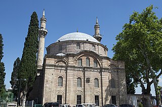
English: Following 1855 Bursa earthquake, the mosque and the mausoleum (Turkish: türbe) of Emir Sultan was rebuilt again in 1868 (1285 A.H) by Sultan Abdülaziz. In 2018 a new restoration was starting. |
Date | |
Source | Own work |
Author | Dosseman |
Camera location | 40° 10′ 50.46″ N, 29° 04′ 51.65″ E ![]() | View this and other nearby images on: OpenStreetMap | ![]() |
---|
Following 1855 Bursa earthquake, the mosque and the mausoleum (Turkish: türbe) of Emir Sultan was rebuilt again in 1868 (1285 A.H) by Sultan Abdülaziz. In 2018 a new restoration was starting.
Licensing
![w:en:Creative Commons](https://upload.wikimedia.org/wikipedia/commons/thumb/7/79/CC_some_rights_reserved.svg/90px-CC_some_rights_reserved.svg.png)
![attribution](https://upload.wikimedia.org/wikipedia/commons/thumb/1/11/Cc-by_new_white.svg/24px-Cc-by_new_white.svg.png)
![share alike](https://upload.wikimedia.org/wikipedia/commons/thumb/d/df/Cc-sa_white.svg/24px-Cc-sa_white.svg.png)
- You are free:
- to share – to copy, distribute and transmit the work
- to remix – to adapt the work
- Under the following conditions:
- attribution – You must give appropriate credit, provide a link to the license, and indicate if changes were made. You may do so in any reasonable manner, but not in any way that suggests the licensor endorses you or your use.
- share alike – If you remix, transform, or build upon the material, you must distribute your contributions under the same or compatible license as the original.
Captions
Items portrayed in this file
depicts
40°10'50.459"N, 29°4'51.647"E
19 May 2014
File history
Click on a date/time to view the file as it appeared at that time.
Date/Time | Thumbnail | Dimensions | User | Comment | |
---|---|---|---|---|---|
current | 20:06, 1 February 2019 | ![]() | 1,600 × 1,065 (439 KB) | commons>Dosseman | User created page with UploadWizard |
File usage
There are no pages that use this file.
Metadata
This file contains additional information, probably added from the digital camera or scanner used to create or digitize it.
If the file has been modified from its original state, some details may not fully reflect the modified file.
Camera manufacturer | NIKON CORPORATION |
---|---|
Camera model | NIKON D4 |
Author | Dick Osseman |
Copyright holder |
|
Exposure time | 1/500 sec (0.002) |
F Number | f/8 |
ISO speed rating | 200 |
Date and time of data generation | 10:24, 19 May 2014 |
Lens focal length | 32 mm |
Latitude | 40° 10′ 50.46″ N |
Longitude | 29° 4′ 51.65″ E |
Altitude | 269 meters above sea level |
Width | 4,928 px |
Height | 3,280 px |
Bits per component |
|
Pixel composition | RGB |
Orientation | Normal |
Number of components | 3 |
Horizontal resolution | 300 dpi |
Vertical resolution | 300 dpi |
Software used | Adobe Photoshop CS6 (Windows) |
File change date and time | 20:30, 1 February 2019 |
Exposure Program | Aperture priority |
Exif version | 2.3 |
Date and time of digitizing | 10:24, 19 May 2014 |
APEX shutter speed | 8.965784 |
APEX aperture | 6 |
APEX exposure bias | 0 |
Maximum land aperture | 3 APEX (f/2.83) |
Metering mode | Pattern |
Light source | Unknown |
Flash | Flash did not fire |
DateTimeOriginal subseconds | 60 |
DateTimeDigitized subseconds | 60 |
Color space | Uncalibrated |
Focal plane X resolution | 1,368.888885498 |
Focal plane Y resolution | 1,368.888885498 |
Focal plane resolution unit | 3 |
Sensing method | One-chip color area sensor |
File source | Digital still camera |
Scene type | A directly photographed image |
Custom image processing | Normal process |
Exposure mode | Auto exposure |
White balance | Auto white balance |
Digital zoom ratio | 1 |
Focal length in 35 mm film | 32 mm |
Scene capture type | Standard |
Scene control | None |
Contrast | Normal |
Saturation | Normal |
Sharpness | Normal |
Subject distance range | Unknown |
GPS time (atomic clock) | 08:24 |
Satellites used for measurement | 08 |
Geodetic survey data used | WGS 84 |
GPS date | 19 May 2014 |
GPS tag version | 0.0.3.2 |
Serial number of camera | 2013761 |
Lens used | 24.0-70.0 mm f/2.8 |
Date metadata was last modified | 21:30, 1 February 2019 |
Unique ID of original document | 85785E87C9763E3B51CD87F57005CC12 |
Keywords |
|
IIM version | 4 |