File:Designated areas in the Everglades.gif
Jump to navigation
Jump to search
No higher resolution available.
Designated_areas_in_the_Everglades.gif (355 × 418 pixels, file size: 18 KB, MIME type: image/gif)

|
File:Designated areas in the Everglades.svg is a vector version of this file. It should be used in place of this GIF file when not inferior.
File:Designated areas in the Everglades.gif → File:Designated areas in the Everglades.svg
For more information, see Help:SVG. |
 |
Summary
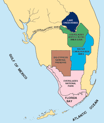
| Description | Map of south Florida showing distribution of federal lands, Water Conservation Areas, and Everglades Agricultural Area. |
| Date | |
| Source | http://sofia.usgs.gov/publications/fs/171-95/ |
| Author | U.S. Geological Survey |
Licensing
This image is in the public domain in the United States because it only contains materials that originally came from the United States Geological Survey, an agency of the United States Department of the Interior. For more information, see the official USGS copyright policy.
|
File history
Click on a date/time to view the file as it appeared at that time.
| Date/Time | Thumbnail | Dimensions | User | Comment | |
|---|---|---|---|---|---|
| current | 02:38, 13 July 2008 | | 355 × 418 (18 KB) | commons>Mr. Absurd | Removed border. |
File usage
There are no pages that use this file.