File:Dallas County Texas Incorporated Areas Sunnyvale highighted.svg
Jump to navigation
Jump to search

Size of this PNG preview of this SVG file: 800 × 457 pixels. Other resolutions: 320 × 183 pixels | 640 × 366 pixels | 1,024 × 585 pixels | 1,280 × 731 pixels | 2,560 × 1,463 pixels.
Original file (SVG file, nominally 1,050 × 600 pixels, file size: 248 KB)
Summary
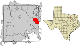
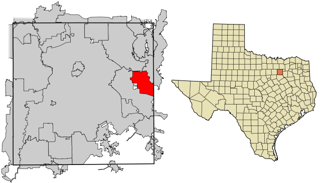
| Description | This map shows the incorporated areas in Dallas County, Texas. Sunnyvale is highlighted in red. I created it in Inkscape using data from the following links: North Central Texas Council of Governments Maps Website, Dallas County Commissioner District Map (PDF) |
| Date | |
| Source | My own work, based on government information. Though I strove to be as accurate in the detail as possible, the information shown is not guaranteed to be completely accurate. |
| Author | Ixnayonthetimmay |
| Permission (Reusing this file) |
Public Domain |
| Other versions | See Category:Maps of Dallas County, Texas for other versions of this image. |
Licensing
| I, the copyright holder of this work, release this work into the public domain. This applies worldwide. In some countries this may not be legally possible; if so: I grant anyone the right to use this work for any purpose, without any conditions, unless such conditions are required by law. |
File history
Click on a date/time to view the file as it appeared at that time.
| Date/Time | Thumbnail | Dimensions | User | Comment | |
|---|---|---|---|---|---|
| current | 18:49, 9 August 2007 | | 1,050 × 600 (248 KB) | commons>Ixnayonthetimmay | == Summary == {{Information |Description=This map shows the incorporated areas in Dallas County, Texas. Sunnyvale is highlighted in red. I created it in [[en:Inkscape |
File usage
There are no pages that use this file.