File:Contour map of Gulf of Mexico 1888.jpg
Jump to navigation
Jump to search
No higher resolution available.
Contour_map_of_Gulf_of_Mexico_1888.jpg (700 × 462 pixels, file size: 137 KB, MIME type: image/jpeg)
Summary
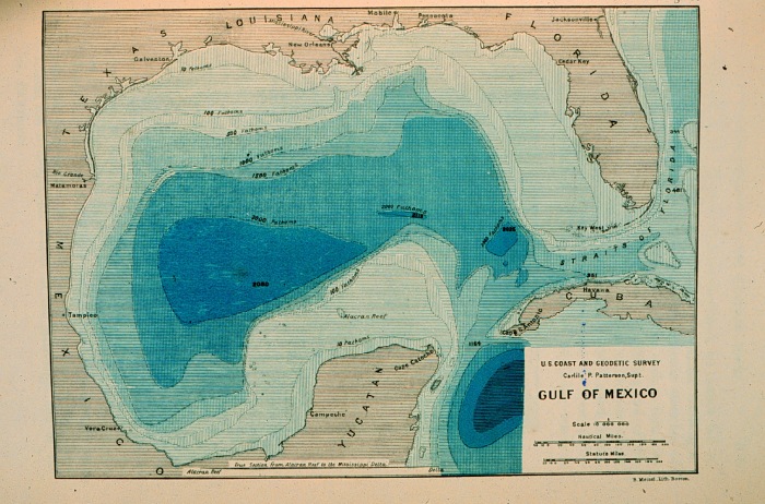
| Description |
English: Contour map of Gulf of Mexico as sounded by the C&GS Steamer BLAKE between 1873 and 1875. Over 3,000 soundings went into this chart, most of the deep water soundings between taken by the Sigsbee Sounding Machine. This was the first realistic bathymetric map of any oceanic basin. In: "Three Cruises of the BLAKE" by Alexander Agassiz, 1888. P. 102. |
| Date | |
| Source | NOAA Central Library Image ID: theb3785, Voyage To Inner Space - Exploring the Seas With NOAA (http://www.photolib.noaa.gov/htmls/theb3785.htm) |
| Author | U.S. Coast and Geodetic Survey |
Licensing
This image is in the public domain because it contains materials that originally came from the U.S. National Oceanic and Atmospheric Administration, taken or made as part of an employee's official duties.
|
Original upload log
The original description page was here. All following user names refer to en.wikipedia.
| Date/Time | Dimensions | User | Comment |
|---|---|---|---|
| 2012-02-10 19:48 | 700×462× (140294 bytes) | Palmeira | {{Information |Description = Contour map of Gulf of Mexico as sounded by the C&GS Steamer BLAKE between 1873 and 1875. Over 3,000 soundings went into this chart, most of the deep water soundings beween taken by the Sigsbee Sounding Machine. This was t |
File history
Click on a date/time to view the file as it appeared at that time.
| Date/Time | Thumbnail | Dimensions | User | Comment | |
|---|---|---|---|---|---|
| current | 03:15, 21 March 2016 | | 700 × 462 (137 KB) | commons>FastilyClone | Transferred from enwp |
File usage
There are no pages that use this file.