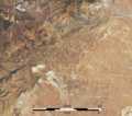
File:Central part of Tehachapi Wind Resource Area (Alta Wind Energy Center, Tehachapi Pass wind farm), California – satellite image with scale bar.png
Jump to navigation
Jump to search

Size of this preview: 677 × 600 pixels. Other resolutions: 271 × 240 pixels | 542 × 480 pixels | 867 × 768 pixels | 1,156 × 1,024 pixels | 1,295 × 1,147 pixels.
Original file (1,295 × 1,147 pixels, file size: 3.4 MB, MIME type: image/png)
File history
Click on a date/time to view the file as it appeared at that time.
| Date/Time | Thumbnail | Dimensions | User | Comment | |
|---|---|---|---|---|---|
| current | 21:47, 23 June 2020 |  | 1,295 × 1,147 (3.4 MB) | commons>A11w1ss3nd | {{Information |description ={{en|1=Satellite image of the central part of the Tehachapi Wind Resource Area in California with its big wind farms Alta Wind Energy Center and Tehachapi Pass wind farm. The wind turbines are connected by both straight and sinuous access roads, which are well visible in this image. On July 1, 2019, Operational Land Imager (OLI) on NASA's Landsat 8 acquired this image. I added a scale bar. }} |date =2019-07-01 |source =https://earthobservatory.na... |
File usage
There are no pages that use this file.