File:Carte Autoroute A4.svg
Jump to navigation
Jump to search

Size of this PNG preview of this SVG file: 600 × 600 pixels. Other resolutions: 240 × 240 pixels | 480 × 480 pixels | 768 × 768 pixels | 1,024 × 1,024 pixels | 2,048 × 2,048 pixels | 2,000 × 2,000 pixels.
Original file (SVG file, nominally 2,000 × 2,000 pixels, file size: 311 KB)
Summary
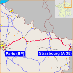
| Description | This is a map showing trace of French A4 motorway. Author: madcap |
| Date | 27 February 2007 (original upload date) |
| Source | No machine-readable source provided. Own work assumed (based on copyright claims). |
| Author | No machine-readable author provided. Madcap assumed (based on copyright claims). |
Licensing
| I, the copyright holder of this work, release this work into the public domain. This applies worldwide. In some countries this may not be legally possible; if so: I grant anyone the right to use this work for any purpose, without any conditions, unless such conditions are required by law. |
File history
Click on a date/time to view the file as it appeared at that time.
| Date/Time | Thumbnail | Dimensions | User | Comment | |
|---|---|---|---|---|---|
| current | 23:50, 27 February 2007 | | 2,000 × 2,000 (311 KB) | commons>Madcap | == Summary == This is a map showing trace of French A4 motorway. Author: madcap == Licensing == {{PD-self}} 004 |
File usage
There are no pages that use this file.