File:Carbon Peak geologic cross section USGS 1987.jpg
Jump to navigation
Jump to search

Size of this preview: 799 × 221 pixels. Other resolutions: 320 × 89 pixels | 1,640 × 454 pixels.
Original file (1,640 × 454 pixels, file size: 267 KB, MIME type: image/jpeg)
File history
Click on a date/time to view the file as it appeared at that time.
| Date/Time | Thumbnail | Dimensions | User | Comment | |
|---|---|---|---|---|---|
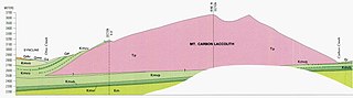
| current | 00:31, 22 November 2020 | 1,640 × 454 (267 KB) | commons>Zapus | Uploaded a work by Gaskill, D.L., Delong, J.E., and Cochran, D.M. from https://ngmdb.usgs.gov/Prodesc/proddesc_1129.htm Gaskill, D.L., Delong, J.E., Jr, and Cochran, D.M.. 1987. Geologic map of the Mt. Axtell quadrangle, Gunnison County, Colorado. Geologic Quadrangle Map GQ-1604. U.S. Geological Survey, Reston, Virginia. with UploadWizard |
File usage
There are no pages that use this file.