File:BAS174 Deception Island with attributes - Operation Tabarin Base B.jpg
Jump to navigation
Jump to search

Size of this preview: 600 × 600 pixels. Other resolutions: 240 × 240 pixels | 480 × 480 pixels | 768 × 768 pixels | 1,024 × 1,024 pixels | 2,048 × 2,048 pixels | 3,374 × 3,374 pixels.
Original file (3,374 × 3,374 pixels, file size: 3.97 MB, MIME type: image/jpeg)
Summary
| Description |
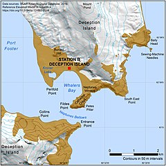
English: Base B, Deception Island, was the first permanently occupied British research station. Opened in February 1944 during Operation Tabarin. This large scale map was created by the digital mapping officer at British Antarctic Survey from the SCAR Antarctic Digital Database. |
| Date | |
| Source | British Antarctic Survey Mapping and Geographic Information Centre mapsales@bas.ac.uk |
| Author | British Antarctic Survey Mapping and Geographic Information Centre |
| Permission (Reusing this file) |
Licensing
This file is licensed under the Creative Commons Attribution-Share Alike 4.0 International license.
- You are free:
- to share – to copy, distribute and transmit the work
- to remix – to adapt the work
- Under the following conditions:
- attribution – You must give appropriate credit, provide a link to the license, and indicate if changes were made. You may do so in any reasonable manner, but not in any way that suggests the licensor endorses you or your use.
- share alike – If you remix, transform, or build upon the material, you must distribute your contributions under the same or compatible license as the original.
File history
Click on a date/time to view the file as it appeared at that time.
| Date/Time | Thumbnail | Dimensions | User | Comment | |
|---|---|---|---|---|---|
| current | 10:01, 19 May 2021 | | 3,374 × 3,374 (3.97 MB) | commons>Buckland1072 | Uploaded a work by British Antarctic Survey Mapping and Geographic Information Centre from British Antarctic Survey Mapping and Geographic Information Centre mapsales@bas.ac.uk with UploadWizard |
File usage
There are no pages that use this file.