File:Azuara-impact-structure-Map.jpg
Jump to navigation
Jump to search

Size of this preview: 800 × 585 pixels. Other resolutions: 320 × 234 pixels | 640 × 468 pixels | 1,024 × 749 pixels.
Original file (1,024 × 749 pixels, file size: 117 KB, MIME type: image/jpeg)
File history
Click on a date/time to view the file as it appeared at that time.
| Date/Time | Thumbnail | Dimensions | User | Comment | |
|---|---|---|---|---|---|
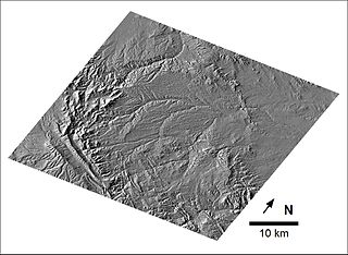
| current | 13:03, 23 March 2008 | | 1,024 × 749 (117 KB) | commons>Descubridor | {{Information |Description= Morphological signature of the Azuara structure taken from the digital map of Spain, 1 : 250,000. The image has been performed by Manuel Cabedo. |Source= own work |Date= 2008-03-23 |Author= Prof. Kord Ernstson |Permission= |
File usage
There are no pages that use this file.