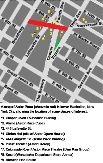
File:Astor Place map locations.jpg
From WikiProjectMed
Jump to navigation
Jump to search
Astor_Place_map_locations.jpg (333 × 524 pixels, file size: 82 KB, MIME type: image/jpeg)
This file is from a shared repository and may be used by other projects. The description on its file description page there is shown below.
Summary
DescriptionAstor Place map locations.jpg |
A schematic map of Astor Place (shown in red) in lower Manhattan, New York City, showing the location of some places of interest:
|
Date | |
Source | Own work |
Author | Beyond My Ken |
Object location | 40° 43′ 47.67″ N, 73° 59′ 27.93″ W ![]() | View this and other nearby images on: OpenStreetMap | ![]() |
---|
Licensing
I, the copyright holder of this work, hereby publish it under the following licenses:
![]() |
Permission is granted to copy, distribute and/or modify this document under the terms of the GNU Free Documentation License, Version 1.2 or any later version published by the Free Software Foundation; with no Invariant Sections, no Front-Cover Texts, and no Back-Cover Texts. A copy of the license is included in the section entitled GNU Free Documentation License.http://www.gnu.org/copyleft/fdl.htmlGFDLGNU Free Documentation Licensetruetrue |
![w:en:Creative Commons](https://upload.wikimedia.org/wikipedia/commons/thumb/7/79/CC_some_rights_reserved.svg/90px-CC_some_rights_reserved.svg.png)
![attribution](https://upload.wikimedia.org/wikipedia/commons/thumb/1/11/Cc-by_new_white.svg/24px-Cc-by_new_white.svg.png)
![share alike](https://upload.wikimedia.org/wikipedia/commons/thumb/d/df/Cc-sa_white.svg/24px-Cc-sa_white.svg.png)
This file is licensed under the Creative Commons Attribution-Share Alike Attribution-Share Alike 4.0 International, 3.0 Unported, 2.5 Generic, 2.0 Generic and 1.0 Generic license.
- You are free:
- to share – to copy, distribute and transmit the work
- to remix – to adapt the work
- Under the following conditions:
- attribution – You must give appropriate credit, provide a link to the license, and indicate if changes were made. You may do so in any reasonable manner, but not in any way that suggests the licensor endorses you or your use.
- share alike – If you remix, transform, or build upon the material, you must distribute your contributions under the same or compatible license as the original.
You may select the license of your choice.
Captions
Add a one-line explanation of what this file represents
Items portrayed in this file
depicts
23 October 2010
40°43'47.672"N, 73°59'27.928"W
image/jpeg
8485b9701ffd98264670f58f47d5b6678e52870d
84,148 byte
524 pixel
333 pixel
File history
Click on a date/time to view the file as it appeared at that time.
Date/Time | Thumbnail | Dimensions | User | Comment | |
---|---|---|---|---|---|
current | 04:07, 6 January 2014 | ![]() | 333 × 524 (82 KB) | commons>Beyond My Ken | black text |
File usage
There are no pages that use this file.
Retrieved from "https://mdwiki.org/wiki/File:Astor_Place_map_locations.jpg"