File:1747 La Feuille Map of Flanders ( Holland and Belgium) - Geographicus - Flandre-lafeuille-1747.jpg
Jump to navigation
Jump to search
Size of this preview: 800 × 560 pixels. Other resolutions: 320 × 224 pixels | 640 × 448 pixels | 1,024 × 716 pixels | 1,280 × 895 pixels | 2,500 × 1,749 pixels.
Original file (2,500 × 1,749 pixels, file size: 1.72 MB, MIME type: image/jpeg)
_-_Geographicus_-_Flandre-lafeuille-1747.jpg)
| Nouvelle Carte Du Comte de Flandre. - Nieuwe Kaart van Vlaanderen.
( |
||||||||||||||||||||
|---|---|---|---|---|---|---|---|---|---|---|---|---|---|---|---|---|---|---|---|---|
| Artist |
|
|||||||||||||||||||
| Title |
Nouvelle Carte Du Comte de Flandre. - Nieuwe Kaart van Vlaanderen. |
|||||||||||||||||||
| Description |
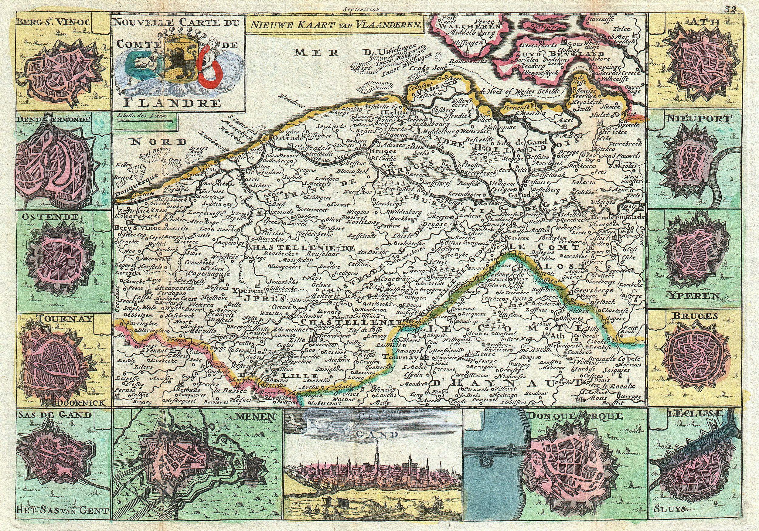
English: A stunning map of Flanders, Italy first drawn by Daniel de la Feuille in 1706. This region includes portions of what is today Belgium and Holland. Surrounded by thirteen views and plans of important villages and fortresses in this region. From top right in a clockwise fashion these include Ath, Nieuport, Yperen, Bruges, L’Ecluse, Donquerque (Dunkirk), Gent (Gand), Menen, Sas de Gand (He Sas van Gent), Tournay (Dooornick), Ostende, Dendermonde and Berg St. Vinoc. Title in upper right quadrant in both French and Dutch surrounding the Flemish armorial shield. This is Paul de la Feuille’s 1747 reissue of his father Daniel’s 1706 map. Prepared for issue as plate no. 38 in J. Ratelband’s 1747 Geographisch-Toneel . |
|||||||||||||||||||
| Date | 1747 (undated) | |||||||||||||||||||
| Dimensions | height: 7 in (17.7 cm); width: 10.2 in (26 cm) | |||||||||||||||||||
| Accession number |
Geographicus link: Flandre-lafeuille-1747 |
|||||||||||||||||||
| Source/Photographer |
Geographisch-Toneel Of uitgezochte Kaarten, Tot gemak der Officieren, Reisigers en Liefhebbers; Behelsende alle de generale Kaarten ..., (1747 J. Ratelband issue.)
|
|||||||||||||||||||
| Permission (Reusing this file) |
|
|||||||||||||||||||
File history
Click on a date/time to view the file as it appeared at that time.
| Date/Time | Thumbnail | Dimensions | User | Comment | |
|---|---|---|---|---|---|
| current | 08:43, 19 March 2011 | | 2,500 × 1,749 (1.72 MB) | commons>BotMultichill | {{subst:User:Multichill/Geographicus |link=http://www.geographicus.com/P/AntiqueMap/Flandre-lafeuille-1747 |product_name=1747 La Feuille Map of Flanders ( Holland and Belgium) |map_title=Nouvelle Carte Du Comte de Flandre. - Nieuwe Kaart van Vlaanderen. | |
File usage
There are no pages that use this file.
_-_Geographicus_-_Flandre-lafeuille-1747.jpg)